Lavumisa geodata
Lavumisa (Shiselweni) is a populated place; located in Eswatini in Africa/Mbabane (GMT+2) time zone. With population of 2,000 people, there are 17 cities with bigger population in this country. Compared to other cities in Eswatini, 100% of cities are located further ↑North; 86.4% of cities are located further ←West and 95.5% of cities have higher elevation than Lavumisa. Note1


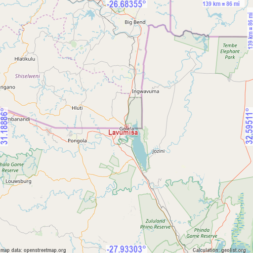
Lavumisa GPS coordinates[2]
27° 18' 36.18" South, 31° 53' 31.128" East
| Map corner | latitude | longitude |
|---|---|---|
| Upper-left | -26.68355°, | 31.18886° |
| Center: | -27.31005°, | 31.89198° |
| Lower-right: | -27.93303°, | 32.59511° |
| Map W x H: | 138.9×138.9 km | = 86.3×86.3mi |
| max Lat: | -25.82659° ⇑100% North |
| Lavumisa: | -27.31005° |
| min Lat: | ⇓0% South -27.31005° |
| min Long | Lavumisa | max Long |
| 31.01667° | 31.89198° | 31.95° |
| W 86.4%⇐ | ⇒13.6% E |
Elevation
Elevation of Lavumisa is 178 m = 584 ft, and this is 500.5 m = 1642 ft below average elevation for this country.
| Max E: |
1317 m = 4321 ft | 95.5% |
| Avg. | 678.5 m = 2226 ft | |
| Lavumisa | 178 m = 584 ft | |
Min E: |
109 m = 358 ft | 4.5% |
See also: Eswatini elevation on elevation.city.
Geographical zone
Lavumisa is located in South temperate zone (between Tropic of Capricorn and the Antarctic Circle). Distance of this Southern Tropic circle is 430.7 km =267.6 mi to North.| Distance of | km | miles | from Lavumisa |
|---|---|---|---|
| Equator | 3036.6 | 1886.9 | to North |
| Tropic Capricorn | 430.7 | 267.6 | to North |
| Antarctic Circle | 4364.6 | 2712 | to South |
| South Pole | 6970.5 | 4331.3 | to South |


Nearby cities:
15 places around Lavumisa: (largest is in red/bold)
• Bhunya
121.1 km =75.2 mi,  314°
314°
• Big Bend
55 km =34.2 mi,  4°
4°
• Hlatikulu
67.1 km =41.7 mi,  303°
303°
• Hluti
29.1 km =18.1 mi,  290°
290°
• Kubuta
62.3 km =38.7 mi,  319°
319°
• Kwaluseni
107.3 km =66.7 mi,  328°
328°
• Lobamba
116.2 km =72.2 mi, 323°
• Malkerns
108.5 km =67.4 mi, 319°
• Manzini
103.5 km =64.3 mi, 330°
• Mbabane
133.7 km =83.1 mi, 325°
• Mhlambanyatsi
129.2 km =80.3 mi, 317°
• Nhlangano
72 km =44.7 mi, 287°
• Nsoko
31.3 km =19.4 mi,  10°
10°
• Sidvokodvo
89.1 km =55.4 mi, 328°
• Siteki
95.5 km =59.3 mi, 3°
Sources, notices
• [Note1] Compared only with cities in Eswatini existing in our database
• [Src1] Map data: © OpenStreetMap contributors (CC-BY-SA)
• [Src2] Other city data from geonames.org with taken over terms of usage.
• [Src3] Geographical zone / Annual Mean Temperature by Robert A. Rohde @ Wikipedia
