Goz Beïda geodata
Goz Beïda (Sila) is a seat of a first-order administrative division; located in Chad in Africa/Ndjamena (GMT+1) time zone. With population of 1,000 people, there are 44 cities with bigger population in this country. Compared to other cities in Chad, 59.6% of cities are located further ↓South; 91.5% of cities are located further ←West and 89.4% of cities have lower elevation than Goz Beïda. Note1


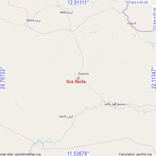
Goz Beïda GPS coordinates[2]
12° 13' 29.424" North, 21° 24' 37.224" East
| Map corner | latitude | longitude |
|---|---|---|
| Upper-left | 12.91111°, | 20.70722° |
| Center: | 12.22484°, | 21.41034° |
| Lower-right: | 11.53678°, | 22.11347° |
| Map W x H: | 152.8×152.8 km | = 94.9×94.9mi |
| max Lat: | 21.8375° ⇑40.4% North |
| Goz Beïda: | 12.22484° |
| min Lat: | ⇓59.6% South 8.26681° |
| min Long | Goz Beïda | max Long |
| 14.1539° | 21.41034° | 22.84308° |
| W 91.5%⇐ | ⇒8.5% E |
Elevation
Elevation of Goz Beïda is 568 m = 1864 ft, and this is 130.7 m = 429 ft above average elevation for this country.
| Max E: |
1046 m = 3432 ft | 10.6% |
| Goz Beïda | 568 m 1864 ft | |
| Avg. | 437.3 m = 1435 ft | |
Min E: |
242 m = 794 ft | 89.4% |
See also: Chad elevation on elevation.city.
Geographical zone
Goz Beïda is located in North Torrid zone (between Equator and Tropic of Cancer). Distance of this Northern Tropic circle is 1246.6 km =774.6 mi to North.| Distance of | km | miles | from Goz Beïda |
|---|---|---|---|
| North Pole | 8647.8 | 5373.5 | to North |
| Arctic Circle | 6041.9 | 3754.3 | to North |
| Tropic Cancer | 1246.6 | 774.6 | to North |
| Equator | 1359.3 | 844.6 | to South |


Nearby cities:
12 places around Goz Beïda: (largest is in red/bold)
• Abéché
189.1 km =117.5 mi,  340°
340°
• Adré
162.4 km =100.9 mi,  31°
31°
• Am Timan
180.9 km =112.4 mi,  222°
222°
• Ati
351.2 km =218.2 mi,  288°
288°
• Biltine
261.3 km =162.4 mi,  348°
348°
• Bitkine
348.6 km =216.6 mi,  265°
265°
• Goz Béïda
213 km =132.4 mi,  333°
333°
• Iriba
334.1 km =207.6 mi,  15°
15°
• Kyabé
409.3 km =254.3 mi, 221°
• Melfi
400 km =248.5 mi,  251°
251°
• Mongo
295.3 km =183.5 mi, 269°
• Oum Hadjer
220.7 km =137.1 mi,  302°
302°
Sources, notices
• [Note1] Compared only with cities in Chad existing in our database
• [Src1] Map data: © OpenStreetMap contributors (CC-BY-SA)
• [Src2] Other city data from geonames.org with taken over terms of usage.
• [Src3] Geographical zone / Annual Mean Temperature by Robert A. Rohde @ Wikipedia
