Goz Béïda geodata
Goz Béïda (Ouadaï) is a populated place; located in Chad in Africa/Ndjamena (GMT+1) time zone. With population of 1,500 people, there are 42 cities with bigger population in this country. Compared to other cities in Chad, 80.9% of cities are located further ↓South; 85.1% of cities are located further ←West and 80.9% of cities have lower elevation than Goz Béïda. Note1


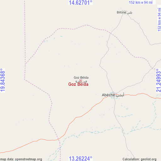
Goz Béïda GPS coordinates[2]
13° 56' 44.268" North, 20° 32' 48.48" East
| Map corner | latitude | longitude |
|---|---|---|
| Upper-left | 14.62701°, | 19.84368° |
| Center: | 13.94563°, | 20.5468° |
| Lower-right: | 13.26224°, | 21.24993° |
| Map W x H: | 151.7×151.8 km | = 94.3×94.3mi |
| max Lat: | 21.8375° ⇑19.1% North |
| Goz Béïda: | 13.94563° |
| min Lat: | ⇓80.9% South 8.26681° |
| min Long | Goz Béïda | max Long |
| 14.1539° | 20.5468° | 22.84308° |
| W 85.1%⇐ | ⇒14.9% E |
Elevation
Elevation of Goz Béïda is 476 m = 1562 ft, and this is 38.7 m = 127 ft above average elevation for this country.
| Max E: |
1046 m = 3432 ft | 19.1% |
| Goz Béïda | 476 m 1562 ft | |
| Avg. | 437.3 m = 1435 ft | |
Min E: |
242 m = 794 ft | 80.9% |
See also: Chad elevation on elevation.city.
Geographical zone
Goz Béïda is located in North Torrid zone (between Equator and Tropic of Cancer). Distance of this Northern Tropic circle is 1055.3 km =655.7 mi to North.| Distance of | km | miles | from Goz Béïda |
|---|---|---|---|
| North Pole | 8456.5 | 5254.6 | to North |
| Arctic Circle | 5850.6 | 3635.4 | to North |
| Tropic Cancer | 1055.3 | 655.7 | to North |
| Equator | 1550.6 | 963.5 | to South |


Nearby cities:
14 places around Goz Béïda: (largest is in red/bold)
• Abéché
33.4 km =20.8 mi,  112°
112°
• Adré
186.2 km =115.7 mi, 106°
• Am Djarass
341.2 km =212 mi,  46°
46°
• Am Timan
325.5 km =202.3 mi,  185°
185°
• Ati
252.4 km =156.8 mi,  251°
251°
• Biltine
76.6 km =47.6 mi,  32°
32°
• Bitkine
334.2 km =207.7 mi,  229°
229°
• Bokoro
415.9 km =258.4 mi, 245°
• Fada
376.9 km =234.2 mi,  17°
17°
• Goz Beïda
213 km =132.4 mi,  153°
153°
• Iriba
224.9 km =139.7 mi, 54°
• Melfi
428.1 km =266 mi,  221°
221°
• Mongo
280.5 km =174.3 mi, 225°
• Oum Hadjer
116.9 km =72.6 mi, 231°
Sources, notices
• [Note1] Compared only with cities in Chad existing in our database
• [Src1] Map data: © OpenStreetMap contributors (CC-BY-SA)
• [Src2] Other city data from geonames.org with taken over terms of usage.
• [Src3] Geographical zone / Annual Mean Temperature by Robert A. Rohde @ Wikipedia
