Bitkine geodata
Bitkine (Guéra) is a populated place; located in Chad in Africa/Ndjamena (GMT+1) time zone. With population of 18,495 people, there are 15 cities with bigger population in this country. Compared to other cities in Chad, 53.2% of cities are located further ↓South; 68.1% of cities are located further ←West and 78.7% of cities have lower elevation than Bitkine. Note1


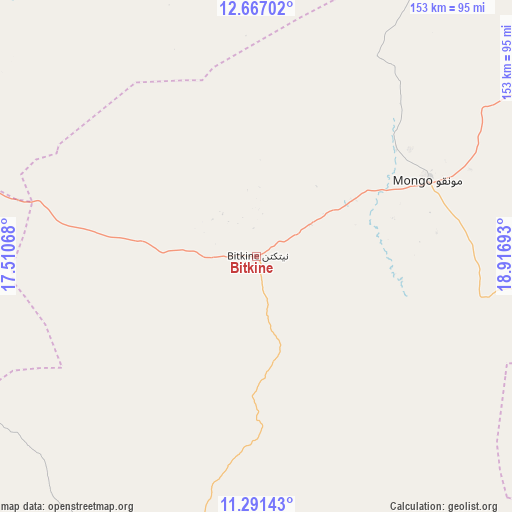
Bitkine GPS coordinates[2]
11° 58' 48.36" North, 18° 12' 49.68" East
| Map corner | latitude | longitude |
|---|---|---|
| Upper-left | 12.66702°, | 17.51068° |
| Center: | 11.9801°, | 18.2138° |
| Lower-right: | 11.29143°, | 18.91693° |
| Map W x H: | 153×153 km | = 95.1×95.1mi |
| max Lat: | 21.8375° ⇑46.8% North |
| Bitkine: | 11.9801° |
| min Lat: | ⇓53.2% South 8.26681° |
| min Long | Bitkine | max Long |
| 14.1539° | 18.2138° | 22.84308° |
| W 68.1%⇐ | ⇒31.9% E |
Elevation
Elevation of Bitkine is 468 m = 1535 ft, and this is 30.7 m = 101 ft above average elevation for this country.
| Max E: |
1046 m = 3432 ft | 21.3% |
| Bitkine | 468 m 1535 ft | |
| Avg. | 437.3 m = 1435 ft | |
Min E: |
242 m = 794 ft | 78.7% |
See also: Chad elevation on elevation.city.
Geographical zone
Bitkine is located in North Torrid zone (between Equator and Tropic of Cancer). Distance of this Northern Tropic circle is 1273.9 km =791.6 mi to North.| Distance of | km | miles | from Bitkine |
|---|---|---|---|
| North Pole | 8675 | 5390.4 | to North |
| Arctic Circle | 6069.1 | 3771.2 | to North |
| Tropic Cancer | 1273.9 | 791.6 | to North |
| Equator | 1332.1 | 827.7 | to South |


Nearby cities:
15 places around Bitkine: (largest is in red/bold)
• Am Timan
249 km =154.7 mi,  115°
115°
• Ati
138 km =85.7 mi,  5°
5°
• Bokoro
133.1 km =82.7 mi,  289°
289°
• Bousso
233.5 km =145.1 mi,  224°
224°
• Dourbali
256.1 km =159.1 mi,  265°
265°
• Goundi
305.4 km =189.8 mi,  197°
197°
• Kyabé
292.3 km =181.6 mi,  164°
164°
• Massaguet
306.8 km =190.6 mi,  280°
280°
• Massakory
292.4 km =181.7 mi, 292°
• Massenya
231.5 km =143.8 mi,  253°
253°
• Melfi
106.7 km =66.3 mi, 196°
• Mongo
56.8 km =35.3 mi,  66°
66°
• Moussoro
262.8 km =163.3 mi,  314°
314°
• Ngama
116 km =72.1 mi,  259°
259°
• Oum Hadjer
217.4 km =135.1 mi,  47°
47°
Sources, notices
• [Note1] Compared only with cities in Chad existing in our database
• [Src1] Map data: © OpenStreetMap contributors (CC-BY-SA)
• [Src2] Other city data from geonames.org with taken over terms of usage.
• [Src3] Geographical zone / Annual Mean Temperature by Robert A. Rohde @ Wikipedia
