Am Timan geodata
Am Timan (Salamat) is a seat of a first-order administrative division; located in Chad in Africa/Ndjamena (GMT+1) time zone. With population of 28,885 people, there are 7 cities with bigger population in this country. Compared to other cities in Chad, 57.4% of cities are located further ↑North; 83% of cities are located further ←West and 74.5% of cities have lower elevation than Am Timan. Note1


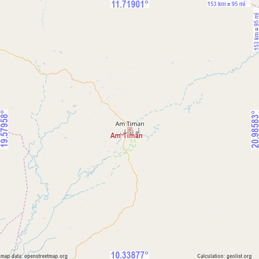
Am Timan GPS coordinates[2]
11° 1' 46.92" North, 20° 16' 57.72" East
| Map corner | latitude | longitude |
|---|---|---|
| Upper-left | 11.71901°, | 19.57958° |
| Center: | 11.0297°, | 20.2827° |
| Lower-right: | 10.33877°, | 20.98583° |
| Map W x H: | 153.5×153.5 km | = 95.4×95.4mi |
| max Lat: | 21.8375° ⇑57.4% North |
| Am Timan: | 11.0297° |
| min Lat: | ⇓42.6% South 8.26681° |
| min Long | Am Timan | max Long |
| 14.1539° | 20.2827° | 22.84308° |
| W 83%⇐ | ⇒17% E |
Elevation
Elevation of Am Timan is 439 m = 1440 ft, and this is 1.7 m = 6 ft above average elevation for this country.
| Max E: |
1046 m = 3432 ft | 25.5% |
| Am Timan | 439 m 1440 ft | |
| Avg. | 437.3 m = 1435 ft | |
Min E: |
242 m = 794 ft | 74.5% |
See also: Chad elevation on elevation.city.
Geographical zone
Am Timan is located in North Torrid zone (between Equator and Tropic of Cancer). Distance of Equator is 1226.4 km =762 mi to South.| Distance of | km | miles | from Am Timan |
|---|---|---|---|
| North Pole | 8780.7 | 5456.1 | to North |
| Arctic Circle | 6174.8 | 3836.8 | to North |
| Tropic Cancer | 1379.5 | 857.2 | to North |
| Equator | 1226.4 | 762 | to South |


Nearby cities:
15 places around Am Timan: (largest is in red/bold)
• Abéché
316.9 km =196.9 mi,  10°
10°
• Adré
341.7 km =212.3 mi,  37°
37°
• Ati
322.3 km =200.3 mi,  318°
318°
• Bitkine
249 km =154.7 mi,  295°
295°
• Bokoro
381.7 km =237.2 mi,  293°
293°
• Goundi
369.1 km =229.3 mi,  239°
239°
• Goz Beïda
180.9 km =112.4 mi, 42°
• Goz Béïda
325.5 km =202.3 mi, 5°
• Koumra
380.4 km =236.4 mi,  231°
231°
• Kyabé
228.5 km =142 mi,  219°
219°
• Melfi
256.2 km =159.2 mi,  270°
270°
• Mongo
215.5 km =133.9 mi,  306°
306°
• Ngama
349.8 km =217.4 mi,  283°
283°
• Oum Hadjer
259.9 km =161.5 mi,  345°
345°
• Sarh
294.7 km =183.1 mi, 224°
Sources, notices
• [Note1] Compared only with cities in Chad existing in our database
• [Src1] Map data: © OpenStreetMap contributors (CC-BY-SA)
• [Src2] Other city data from geonames.org with taken over terms of usage.
• [Src3] Geographical zone / Annual Mean Temperature by Robert A. Rohde @ Wikipedia
