Ati geodata
Ati (Batha) is a seat of a first-order administrative division; located in Chad in Africa/Ndjamena (GMT+1) time zone. With population of 24,074 people, there are 11 cities with bigger population in this country. Compared to other cities in Chad, 68.1% of cities are located further ↓South; 70.2% of cities are located further ←West and 70.2% of cities have higher elevation than Ati. Note1


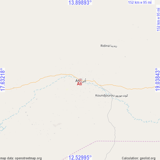
Ati GPS coordinates[2]
13° 12' 55.44" North, 18° 20' 7.08" East
| Map corner | latitude | longitude |
|---|---|---|
| Upper-left | 13.89893°, | 17.63218° |
| Center: | 13.2154°, | 18.3353° |
| Lower-right: | 12.52995°, | 19.03843° |
| Map W x H: | 152.2×152.2 km | = 94.6×94.6mi |
| max Lat: | 21.8375° ⇑31.9% North |
| Ati: | 13.2154° |
| min Lat: | ⇓68.1% South 8.26681° |
| min Long | Ati | max Long |
| 14.1539° | 18.3353° | 22.84308° |
| W 70.2%⇐ | ⇒29.8% E |
Elevation
Elevation of Ati is 336 m = 1102 ft, and this is 101.3 m = 332 ft below average elevation for this country.
| Max E: |
1046 m = 3432 ft | 70.2% |
| Avg. | 437.3 m = 1435 ft | |
| Ati | 336 m = 1102 ft | |
Min E: |
242 m = 794 ft | 29.8% |
See also: Chad elevation on elevation.city.
Geographical zone
Ati is located in North Torrid zone (between Equator and Tropic of Cancer). Distance of this Northern Tropic circle is 1136.5 km =706.2 mi to North.| Distance of | km | miles | from Ati |
|---|---|---|---|
| North Pole | 8537.6 | 5305 | to North |
| Arctic Circle | 5931.8 | 3685.8 | to North |
| Tropic Cancer | 1136.5 | 706.2 | to North |
| Equator | 1469.4 | 913 | to South |


Nearby cities:
15 places around Ati: (largest is in red/bold)
• Abéché
278.4 km =173 mi,  75°
75°
• Am Timan
322.3 km =200.3 mi,  138°
138°
• Biltine
315.6 km =196.1 mi,  62°
62°
• Bitkine
138 km =85.7 mi,  185°
185°
• Bokoro
166.8 km =103.6 mi,  236°
236°
• Dourbali
310.4 km =192.9 mi, 239°
• Goz Béïda
252.4 km =156.8 mi,  71°
71°
• Massaguet
324.8 km =201.8 mi,  255°
255°
• Massakory
283.3 km =176 mi,  265°
265°
• Massenya
309.6 km =192.4 mi,  229°
229°
• Melfi
243.6 km =151.4 mi, 190°
• Mongo
121 km =75.2 mi,  161°
161°
• Moussoro
205.2 km =127.5 mi,  283°
283°
• Ngama
203.6 km =126.5 mi,  218°
218°
• Oum Hadjer
147.6 km =91.7 mi,  86°
86°
Sources, notices
• [Note1] Compared only with cities in Chad existing in our database
• [Src1] Map data: © OpenStreetMap contributors (CC-BY-SA)
• [Src2] Other city data from geonames.org with taken over terms of usage.
• [Src3] Geographical zone / Annual Mean Temperature by Robert A. Rohde @ Wikipedia
