Takua Pa geodata
Takua Pa (Phangnga) is a seat of a second-order administrative division; located in Thailand in Asia/Bangkok (GMT+7) time zone. In our database, there are 331 cities with bigger population. Compared to other cities in Thailand, 85.2% of cities are located further ↑North; 98% of cities are located further →East and 80.8% of cities have higher elevation than Takua Pa. Note1


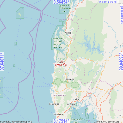
Takua Pa GPS coordinates[2]
8° 52' 13.8" North, 98° 20' 37.788" East
| Map corner | latitude | longitude |
|---|---|---|
| Upper-left | 9.56454°, | 97.64071° |
| Center: | 8.8705°, | 98.34383° |
| Lower-right: | 8.17514°, | 99.04696° |
| Map W x H: | 154.5×154.5 km | = 96×96mi |
| max Lat: | 20.43353° ⇑85.2% North |
| Takua Pa: | 8.8705° |
| min Lat: | ⇓14.8% South 5.77434° |
| min Long | Takua Pa | max Long |
| 97.93288° | 98.34383° | 105.49506° |
| W 2%⇐ | ⇒98% E |
Elevation
Elevation of Takua Pa is 12 m = 39 ft, and this is 113.5 m = 372 ft below average elevation for this country.
| Max E: |
1011 m = 3317 ft | 80.8% |
| Avg. | 125.5 m = 412 ft | |
| Takua Pa | 12 m = 39 ft | |
Min E: |
1 m = 3 ft | 19.2% |
See also: Thailand elevation on elevation.city.
Geographical zone
Takua Pa is located in North Torrid zone (between Equator and Tropic of Cancer). Distance of Equator is 986.3 km =612.9 mi to South.| Distance of | km | miles | from Takua Pa |
|---|---|---|---|
| North Pole | 9020.8 | 5605.3 | to North |
| Arctic Circle | 6414.9 | 3986 | to North |
| Tropic Cancer | 1619.6 | 1006.4 | to North |
| Equator | 986.3 | 612.9 | to South |


Nearby cities:
15 places around Takua Pa: (largest is in red/bold)
• Ao Luek
68.7 km =42.7 mi,  142°
142°
• Ban Khao Lak
30.6 km =19 mi,  201°
201°
• Ban Mai Khao
82.8 km =51.4 mi,  182°
182°
• Ban Takhun
59.5 km =37 mi,  86°
86°
• Kapong
20.6 km =12.8 mi,  159°
159°
• Khura Buri
36.8 km =22.9 mi,  12°
12°
• Phang Nga
50.9 km =31.6 mi, 156°
• Phanom
51.5 km =32 mi, 91°
• Plai Phraya
68.4 km =42.5 mi,  123°
123°
• Suk Samran
53.5 km =33.2 mi, 10°
• Takua Thung
55.4 km =34.4 mi,  167°
167°
• Takuk Nuea
80.8 km =50.2 mi,  59°
59°
• Tha Khanon
69.2 km =43 mi,  75°
75°
• Thai Mueang
53.2 km =33.1 mi,  189°
189°
• Thap Put
51.1 km =31.8 mi, 140°
Sources, notices
• [Note1] Compared only with cities in Thailand existing in our database
• [Src1] Map data: © OpenStreetMap contributors (CC-BY-SA)
• [Src2] Other city data from geonames.org with taken over terms of usage.
• [Src3] Geographical zone / Annual Mean Temperature by Robert A. Rohde @ Wikipedia
