Ban Khao Lak geodata
Ban Khao Lak (Phangnga) is a populated place; located in Thailand in Asia/Bangkok (GMT+7) time zone. With population of 1,700 people, there are 322 cities with bigger population in this country. Compared to other cities in Thailand, 86% of cities are located further ↑North; 99.3% of cities are located further →East and 70.3% of cities have higher elevation than Ban Khao Lak. Note1


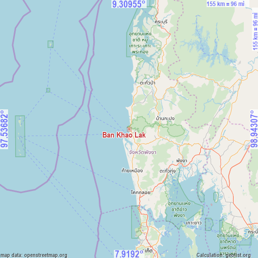
Ban Khao Lak GPS coordinates[2]
8° 36' 54.036" North, 98° 14' 23.784" East
| Map corner | latitude | longitude |
|---|---|---|
| Upper-left | 9.30955°, | 97.53682° |
| Center: | 8.61501°, | 98.23994° |
| Lower-right: | 7.9192°, | 98.94307° |
| Map W x H: | 154.6×154.6 km | = 96.1×96.1mi |
| max Lat: | 20.43353° ⇑86% North |
| Ban Khao Lak: | 8.61501° |
| min Lat: | ⇓14% South 5.77434° |
| min Long | Ban Khao Lak | max Long |
| 97.93288° | 98.23994° | 105.49506° |
| W 0.7%⇐ | ⇒99.3% E |
Elevation
Elevation of Ban Khao Lak is 22 m = 72 ft, and this is 103.5 m = 340 ft below average elevation for this country.
| Max E: |
1011 m = 3317 ft | 70.3% |
| Avg. | 125.5 m = 412 ft | |
| Ban Khao Lak | 22 m = 72 ft | |
Min E: |
1 m = 3 ft | 29.7% |
See also: Thailand elevation on elevation.city.
Geographical zone
Ban Khao Lak is located in North Torrid zone (between Equator and Tropic of Cancer). Distance of Equator is 957.9 km =595.2 mi to South.| Distance of | km | miles | from Ban Khao Lak |
|---|---|---|---|
| North Pole | 9049.2 | 5622.9 | to North |
| Arctic Circle | 6443.3 | 4003.7 | to North |
| Tropic Cancer | 1648 | 1024 | to North |
| Equator | 957.9 | 595.2 | to South |


Nearby cities:
15 places around Ban Khao Lak: (largest is in red/bold)
• Ao Luek
59.1 km =36.7 mi,  116°
116°
• Ban Ko Kaeo
77.4 km =48.1 mi,  167°
167°
• Ban Mai Khao
54.8 km =34.1 mi, 172°
• Ban Takhun
77.8 km =48.3 mi,  65°
65°
• Kapong
20.7 km =12.9 mi,  63°
63°
• Khura Buri
67.2 km =41.8 mi,  16°
16°
• Ko Yao
68.2 km =42.4 mi,  145°
145°
• Phang Nga
36.7 km =22.8 mi, 119°
• Phanom
68.4 km =42.5 mi, 67°
• Plai Phraya
69.2 km =43 mi,  97°
97°
• Takua Pa
30.6 km =19 mi, 21°
• Takua Thung
34.7 km =21.6 mi,  137°
137°
• Thai Mueang
24.1 km =15 mi, 174°
• Thalang
65.7 km =40.8 mi, 170°
• Thap Put
45.3 km =28.1 mi, 104°
Sources, notices
• [Note1] Compared only with cities in Thailand existing in our database
• [Src1] Map data: © OpenStreetMap contributors (CC-BY-SA)
• [Src2] Other city data from geonames.org with taken over terms of usage.
• [Src3] Geographical zone / Annual Mean Temperature by Robert A. Rohde @ Wikipedia
