Wan Yai geodata
Wan Yai (Mukdahan) is a seat of a second-order administrative division; located in Thailand in Asia/Bangkok (GMT+7) time zone. In our database, there are 331 cities with bigger population. Compared to other cities in Thailand, 75.2% of cities are located further ↓South; 97.2% of cities are located further ←West and 62% of cities have lower elevation than Wan Yai. Note1


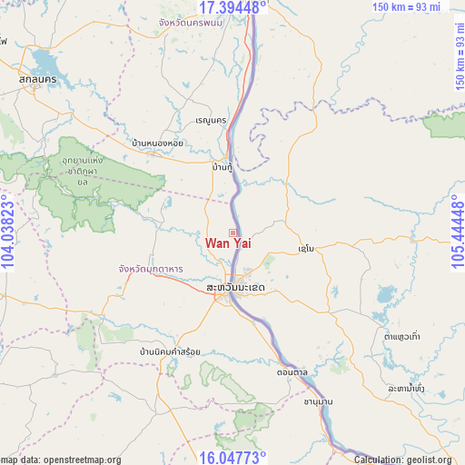
Wan Yai GPS coordinates[2]
16° 43' 20.244" North, 104° 44' 28.86" East
| Map corner | latitude | longitude |
|---|---|---|
| Upper-left | 17.39448°, | 104.03823° |
| Center: | 16.72229°, | 104.74135° |
| Lower-right: | 16.04773°, | 105.44448° |
| Map W x H: | 149.7×149.7 km | = 93×93mi |
| max Lat: | 20.43353° ⇑24.8% North |
| Wan Yai: | 16.72229° |
| min Lat: | ⇓75.2% South 5.77434° |
| min Long | Wan Yai | max Long |
| 97.93288° | 104.74135° | 105.49506° |
| W 97.2%⇐ | ⇒2.8% E |
Elevation
Elevation of Wan Yai is 153 m = 502 ft, and this is 27.5 m = 90 ft above average elevation for this country.
| Max E: |
1011 m = 3317 ft | 38% |
| Wan Yai | 153 m 502 ft | |
| Avg. | 125.5 m = 412 ft | |
Min E: |
1 m = 3 ft | 62% |
See also: Thailand elevation on elevation.city.
Geographical zone
Wan Yai is located in North Torrid zone (between Equator and Tropic of Cancer). Distance of this Northern Tropic circle is 746.6 km =463.9 mi to North.| Distance of | km | miles | from Wan Yai |
|---|---|---|---|
| North Pole | 8147.7 | 5062.7 | to North |
| Arctic Circle | 5541.8 | 3443.5 | to North |
| Tropic Cancer | 746.6 | 463.9 | to North |
| Equator | 1859.3 | 1155.3 | to South |


Nearby cities:
15 places around Wan Yai: (largest is in red/bold)
• Chanuman
61 km =37.9 mi,  153°
153°
• Don Tan
48.9 km =30.4 mi,  157°
157°
• Dong Luang
24 km =14.9 mi,  295°
295°
• Khamcha-i
37.9 km =23.5 mi,  244°
244°
• Khok Si Suphan
61.2 km =38 mi,  305°
305°
• Loeng Nok Tha
60.6 km =37.7 mi,  199°
199°
• Mukdahan
19.8 km =12.3 mi,  185°
185°
• Na Kae
35.7 km =22.2 mi, 314°
• Nikhom Kham Soi
43.9 km =27.3 mi,  207°
207°
• Nong Sung
49.7 km =30.9 mi, 237°
• Pla Pak
55.9 km =34.7 mi,  335°
335°
• Renu Nakhon
37.2 km =23.1 mi,  349°
349°
• Tao Ngoi
68.3 km =42.4 mi, 296°
• That Phanom
24 km =14.9 mi, 352°
• Wang Yang
48.3 km =30 mi,  320°
320°
Sources, notices
• [Note1] Compared only with cities in Thailand existing in our database
• [Src1] Map data: © OpenStreetMap contributors (CC-BY-SA)
• [Src2] Other city data from geonames.org with taken over terms of usage.
• [Src3] Geographical zone / Annual Mean Temperature by Robert A. Rohde @ Wikipedia
