Mukdahan geodata
Mukdahan is a seat of a first-order administrative division; located in Thailand in Asia/Bangkok (GMT+7) time zone. With population of 40,480 people, there are 76 cities with bigger population in this country. Compared to other cities in Thailand, 72.8% of cities are located further ↓South; 96.9% of cities are located further ←West and 58.5% of cities have lower elevation than Mukdahan. Note1


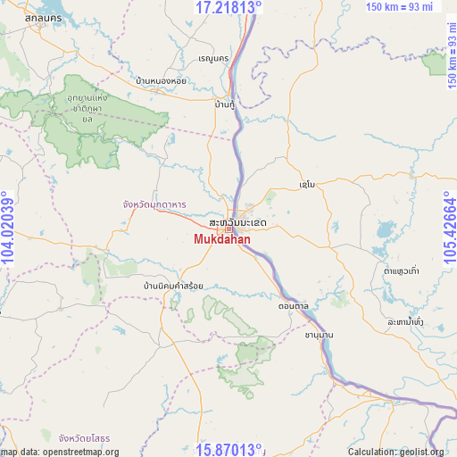
Mukdahan GPS coordinates[2]
16° 32' 43.116" North, 104° 43' 24.636" East
| Map corner | latitude | longitude |
|---|---|---|
| Upper-left | 17.21813°, | 104.02039° |
| Center: | 16.54531°, | 104.72351° |
| Lower-right: | 15.87013°, | 105.42664° |
| Map W x H: | 149.9×149.9 km | = 93.1×93.1mi |
| max Lat: | 20.43353° ⇑27.2% North |
| Mukdahan: | 16.54531° |
| min Lat: | ⇓72.8% South 5.77434° |
| min Long | Mukdahan | max Long |
| 97.93288° | 104.72351° | 105.49506° |
| W 96.9%⇐ | ⇒3.1% E |
Elevation
Elevation of Mukdahan is 145 m = 476 ft, and this is 19.5 m = 64 ft above average elevation for this country.
| Max E: |
1011 m = 3317 ft | 41.5% |
| Mukdahan | 145 m 476 ft | |
| Avg. | 125.5 m = 412 ft | |
Min E: |
1 m = 3 ft | 58.5% |
See also: Mukdahan elevation on elevation.city.
Geographical zone
Mukdahan is located in North Torrid zone (between Equator and Tropic of Cancer). Distance of this Northern Tropic circle is 766.3 km =476.2 mi to North.| Distance of | km | miles | from Mukdahan |
|---|---|---|---|
| North Pole | 8167.4 | 5075 | to North |
| Arctic Circle | 5561.5 | 3455.8 | to North |
| Tropic Cancer | 766.3 | 476.2 | to North |
| Equator | 1839.7 | 1143.1 | to South |


Nearby cities:
15 places around Mukdahan: (largest is in red/bold)
• Chanuman
45.5 km =28.3 mi,  139°
139°
• Don Tan
32.9 km =20.4 mi, 140°
• Dong Luang
36 km =22.4 mi,  326°
326°
• Khamcha-i
32.6 km =20.3 mi,  276°
276°
• Loeng Nok Tha
41.6 km =25.8 mi,  205°
205°
• Moeiwadi
62.8 km =39 mi,  253°
253°
• Na Kae
50.5 km =31.4 mi, 332°
• Nikhom Kham Soi
26.6 km =16.5 mi,  223°
223°
• Nong Phok
61.4 km =38.2 mi,  244°
244°
• Nong Sung
40.7 km =25.3 mi,  260°
260°
• Renu Nakhon
56.5 km =35.1 mi,  354°
354°
• Senangkhanikhom
56.5 km =35.1 mi,  185°
185°
• Thai Charoen
61.2 km =38 mi, 209°
• That Phanom
43.5 km =27 mi,  358°
358°
• Wan Yai
19.8 km =12.3 mi,  5°
5°
Sources, notices
• [Note1] Compared only with cities in Thailand existing in our database
• [Src1] Map data: © OpenStreetMap contributors (CC-BY-SA)
• [Src2] Other city data from geonames.org with taken over terms of usage.
• [Src3] Geographical zone / Annual Mean Temperature by Robert A. Rohde @ Wikipedia
