Nikhom Kham Soi geodata
Nikhom Kham Soi (Mukdahan) is a seat of a second-order administrative division; located in Thailand in Asia/Bangkok (GMT+7) time zone. In our database, there are 331 cities with bigger population. Compared to other cities in Thailand, 70.3% of cities are located further ↓South; 95.7% of cities are located further ←West and 77.3% of cities have lower elevation than Nikhom Kham Soi. Note1


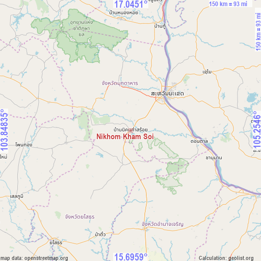
Nikhom Kham Soi GPS coordinates[2]
16° 22' 18.012" North, 104° 33' 5.292" East
| Map corner | latitude | longitude |
|---|---|---|
| Upper-left | 17.0451°, | 103.84835° |
| Center: | 16.37167°, | 104.55147° |
| Lower-right: | 15.6959°, | 105.2546° |
| Map W x H: | 150×150 km | = 93.2×93.2mi |
| max Lat: | 20.43353° ⇑29.7% North |
| Nikhom Kham Soi: | 16.37167° |
| min Lat: | ⇓70.3% South 5.77434° |
| min Long | Nikhom Kham Soi | max Long |
| 97.93288° | 104.55147° | 105.49506° |
| W 95.7%⇐ | ⇒4.3% E |
Elevation
Elevation of Nikhom Kham Soi is 189 m = 620 ft, and this is 63.5 m = 208 ft above average elevation for this country.
| Max E: |
1011 m = 3317 ft | 22.7% |
| Nikhom Kham Soi | 189 m 620 ft | |
| Avg. | 125.5 m = 412 ft | |
Min E: |
1 m = 3 ft | 77.3% |
See also: Thailand elevation on elevation.city.
Geographical zone
Nikhom Kham Soi is located in North Torrid zone (between Equator and Tropic of Cancer). Distance of this Northern Tropic circle is 785.6 km =488.1 mi to North.| Distance of | km | miles | from Nikhom Kham Soi |
|---|---|---|---|
| North Pole | 8186.7 | 5087 | to North |
| Arctic Circle | 5580.8 | 3467.7 | to North |
| Tropic Cancer | 785.6 | 488.1 | to North |
| Equator | 1820.4 | 1131.1 | to South |


Nearby cities:
15 places around Nikhom Kham Soi: (largest is in red/bold)
• Amnat Charoen
57.7 km =35.9 mi,  171°
171°
• Chanuman
50.3 km =31.3 mi,  107°
107°
• Don Tan
39.8 km =24.7 mi,  98°
98°
• Dong Luang
49.4 km =30.7 mi,  358°
358°
• Khamcha-i
26.9 km =16.7 mi,  328°
328°
• Kuchinarai
56.7 km =35.2 mi,  289°
289°
• Kut Chum
44 km =27.3 mi,  211°
211°
• Loeng Nok Tha
18.3 km =11.4 mi,  178°
178°
• Moeiwadi
42.1 km =26.2 mi,  272°
272°
• Mukdahan
26.6 km =16.5 mi,  43°
43°
• Nong Phok
37.9 km =23.5 mi,  259°
259°
• Nong Sung
25.1 km =15.6 mi,  299°
299°
• Senangkhanikhom
39 km =24.2 mi,  161°
161°
• Thai Charoen
36 km =22.4 mi,  199°
199°
• Wan Yai
43.9 km =27.3 mi,  27°
27°
Sources, notices
• [Note1] Compared only with cities in Thailand existing in our database
• [Src1] Map data: © OpenStreetMap contributors (CC-BY-SA)
• [Src2] Other city data from geonames.org with taken over terms of usage.
• [Src3] Geographical zone / Annual Mean Temperature by Robert A. Rohde @ Wikipedia
