Chai Badan geodata
Chai Badan (Lop Buri) is a populated place; located in Thailand in Asia/Bangkok (GMT+7) time zone. With population of 25,196 people, there are 127 cities with bigger population in this country. Compared to other cities in Thailand, 52.7% of cities are located further ↓South; 56.6% of cities are located further ←West and 60.2% of cities have higher elevation than Chai Badan. Note1


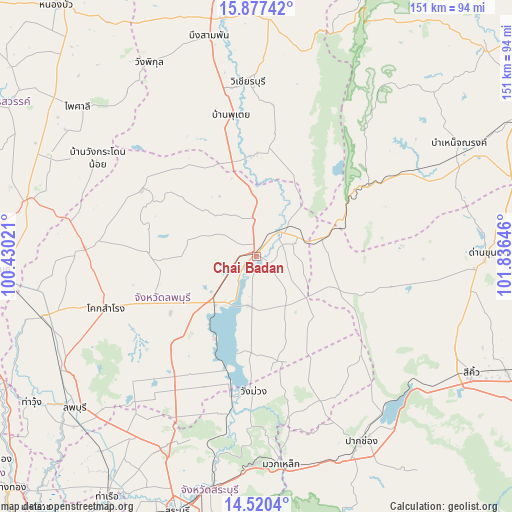
Chai Badan GPS coordinates[2]
15° 12' 0" North, 101° 7' 59.988" East
| Map corner | latitude | longitude |
|---|---|---|
| Upper-left | 15.87742°, | 100.43021° |
| Center: | 15.2°, | 101.13333° |
| Lower-right: | 14.5204°, | 101.83646° |
| Map W x H: | 150.9×150.9 km | = 93.8×93.8mi |
| max Lat: | 20.43353° ⇑47.3% North |
| Chai Badan: | 15.2° |
| min Lat: | ⇓52.7% South 5.77434° |
| min Long | Chai Badan | max Long |
| 97.93288° | 101.13333° | 105.49506° |
| W 56.6%⇐ | ⇒43.4% E |
Elevation
Elevation of Chai Badan is 44 m = 144 ft, and this is 81.5 m = 267 ft below average elevation for this country.
| Max E: |
1011 m = 3317 ft | 60.2% |
| Avg. | 125.5 m = 412 ft | |
| Chai Badan | 44 m = 144 ft | |
Min E: |
1 m = 3 ft | 39.8% |
See also: Thailand elevation on elevation.city.
Geographical zone
Chai Badan is located in North Torrid zone (between Equator and Tropic of Cancer). Distance of this Northern Tropic circle is 915.8 km =569.1 mi to North.| Distance of | km | miles | from Chai Badan |
|---|---|---|---|
| North Pole | 8317 | 5167.9 | to North |
| Arctic Circle | 5711.1 | 3548.7 | to North |
| Tropic Cancer | 915.8 | 569.1 | to North |
| Equator | 1690.1 | 1050.2 | to South |


Nearby cities:
15 places around Chai Badan: (largest is in red/bold)
• Khok Charoen
39.2 km =24.4 mi,  300°
300°
• Khok Samrong
46.5 km =28.9 mi,  251°
251°
• Lam Sonthi
27.2 km =16.9 mi,  65°
65°
• Muak Lek
61.3 km =38.1 mi,  173°
173°
• Nong Muang
51.5 km =32 mi,  275°
275°
• Pak Chong
62.6 km =38.9 mi,  150°
150°
• Phatthana Nikhom
41.4 km =25.7 mi,  202°
202°
• Phra Phutthabat
64.1 km =39.8 mi,  214°
214°
• Sa Bot
32.5 km =20.2 mi,  271°
271°
• Si Thep
28.9 km =18 mi,  345°
345°
• Tha Luang
14.8 km =9.2 mi,  194°
194°
• Thep Sathit
40.2 km =25 mi,  57°
57°
• Thepharak
46.3 km =28.8 mi, 74°
• Wang Muang
39.8 km =24.7 mi,  181°
181°
• Wichian Buri
51 km =31.7 mi,  356°
356°
Sources, notices
• [Note1] Compared only with cities in Thailand existing in our database
• [Src1] Map data: © OpenStreetMap contributors (CC-BY-SA)
• [Src2] Other city data from geonames.org with taken over terms of usage.
• [Src3] Geographical zone / Annual Mean Temperature by Robert A. Rohde @ Wikipedia
