Den Chai geodata
Den Chai (Phrae) is a seat of a second-order administrative division; located in Thailand in Asia/Bangkok (GMT+7) time zone. With population of 17,019 people, there are 187 cities with bigger population in this country. Compared to other cities in Thailand, 88.5% of cities are located further ↓South; 71% of cities are located further →East and 64.7% of cities have lower elevation than Den Chai. Note1


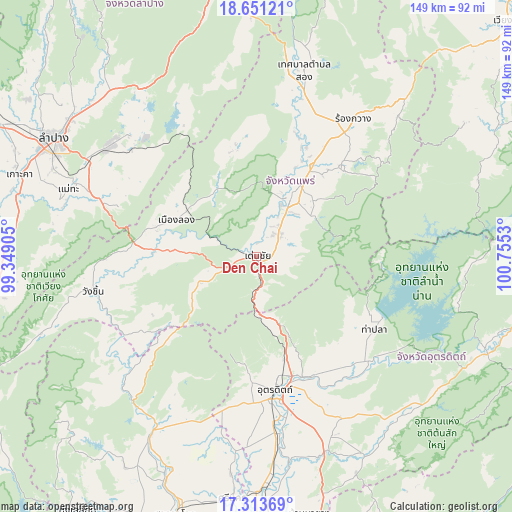
Den Chai GPS coordinates[2]
17° 59' 1.392" North, 100° 3' 7.812" East
| Map corner | latitude | longitude |
|---|---|---|
| Upper-left | 18.65121°, | 99.34905° |
| Center: | 17.98372°, | 100.05217° |
| Lower-right: | 17.31369°, | 100.7553° |
| Map W x H: | 148.7×148.7 km | = 92.4×92.4mi |
| max Lat: | 20.43353° ⇑11.5% North |
| Den Chai: | 17.98372° |
| min Lat: | ⇓88.5% South 5.77434° |
| min Long | Den Chai | max Long |
| 97.93288° | 100.05217° | 105.49506° |
| W 29%⇐ | ⇒71% E |
Elevation
Elevation of Den Chai is 159 m = 522 ft, and this is 33.5 m = 110 ft above average elevation for this country.
| Max E: |
1011 m = 3317 ft | 35.3% |
| Den Chai | 159 m 522 ft | |
| Avg. | 125.5 m = 412 ft | |
Min E: |
1 m = 3 ft | 64.7% |
See also: Thailand elevation on elevation.city.
Geographical zone
Den Chai is located in North Torrid zone (between Equator and Tropic of Cancer). Distance of this Northern Tropic circle is 606.3 km =376.7 mi to North.| Distance of | km | miles | from Den Chai |
|---|---|---|---|
| North Pole | 8007.5 | 4975.6 | to North |
| Arctic Circle | 5401.6 | 3356.4 | to North |
| Tropic Cancer | 606.3 | 376.7 | to North |
| Equator | 1999.6 | 1242.5 | to South |


Nearby cities:
15 places around Den Chai: (largest is in red/bold)
• Lap Lae
36.9 km =22.9 mi,  182°
182°
• Laplae
36.9 km =22.9 mi, 182°
• Long
25.5 km =15.8 mi,  293°
293°
• Mae Mo
53.4 km =33.2 mi,  307°
307°
• Mae Tha
59.3 km =36.8 mi, 286°
• Nong Muang Khai
34.4 km =21.4 mi,  24°
24°
• Phrae
20.3 km =12.6 mi,  27°
27°
• Rong Kwang
48.4 km =30.1 mi,  35°
35°
• Si Satchanalai
60.4 km =37.5 mi,  210°
210°
• Song
56 km =34.8 mi,  14°
14°
• Sung Men
9.8 km =6.1 mi, 42°
• Tha Pla
40.4 km =25.1 mi,  121°
121°
• Tron
56.2 km =34.9 mi,  173°
173°
• Uttaradit
40.1 km =24.9 mi, 173°
• Wang Chin
48.1 km =29.9 mi,  256°
256°
Sources, notices
• [Note1] Compared only with cities in Thailand existing in our database
• [Src1] Map data: © OpenStreetMap contributors (CC-BY-SA)
• [Src2] Other city data from geonames.org with taken over terms of usage.
• [Src3] Geographical zone / Annual Mean Temperature by Robert A. Rohde @ Wikipedia
