Ban Khok geodata
Ban Khok (Uttaradit) is a seat of a second-order administrative division; located in Thailand in Asia/Bangkok (GMT+7) time zone. In our database, there are 331 cities with bigger population. Compared to other cities in Thailand, 89.3% of cities are located further ↓South; 55.2% of cities are located further ←West and 96.8% of cities have lower elevation than Ban Khok. Note1


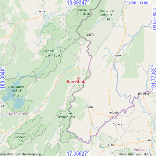
Ban Khok GPS coordinates[2]
18° 1' 34.104" North, 101° 4' 3.792" East
| Map corner | latitude | longitude |
|---|---|---|
| Upper-left | 18.69347°, | 100.3646° |
| Center: | 18.02614°, | 101.06772° |
| Lower-right: | 17.35627°, | 101.77085° |
| Map W x H: | 148.7×148.7 km | = 92.4×92.4mi |
| max Lat: | 20.43353° ⇑10.7% North |
| Ban Khok: | 18.02614° |
| min Lat: | ⇓89.3% South 5.77434° |
| min Long | Ban Khok | max Long |
| 97.93288° | 101.06772° | 105.49506° |
| W 55.2%⇐ | ⇒44.8% E |
Elevation
Elevation of Ban Khok is 433 m = 1421 ft, and this is 307.5 m = 1009 ft above average elevation for this country.
| Max E: |
1011 m = 3317 ft | 3.2% |
| Ban Khok | 433 m 1421 ft | |
| Avg. | 125.5 m = 412 ft | |
Min E: |
1 m = 3 ft | 96.8% |
See also: Thailand elevation on elevation.city.
Geographical zone
Ban Khok is located in North Torrid zone (between Equator and Tropic of Cancer). Distance of this Northern Tropic circle is 601.6 km =373.8 mi to North.| Distance of | km | miles | from Ban Khok |
|---|---|---|---|
| North Pole | 8002.7 | 4972.6 | to North |
| Arctic Circle | 5396.9 | 3353.5 | to North |
| Tropic Cancer | 601.6 | 373.8 | to North |
| Equator | 2004.3 | 1245.4 | to South |


Nearby cities:
15 places around Ban Khok: (largest is in red/bold)
• Chiang Khan
64.3 km =40 mi,  103°
103°
• Dan Sai
83.4 km =51.8 mi,  174°
174°
• Fak Tha
20.1 km =12.5 mi,  261°
261°
• Mae Charim
75.9 km =47.2 mi,  355°
355°
• Na Haeo
60.1 km =37.3 mi,  179°
179°
• Na Muen
46.7 km =29 mi,  292°
292°
• Na Noi
50.1 km =31.1 mi,  311°
311°
• Nam Pat
52.4 km =32.6 mi,  230°
230°
• Pak Chom
87.8 km =54.6 mi,  90°
90°
• Phu Phiang
84.5 km =52.5 mi,  340°
340°
• Phu Ruea
70.9 km =44.1 mi,  153°
153°
• Rong Kwang
86.6 km =53.8 mi, 293°
• Tha Li
58.3 km =36.2 mi,  140°
140°
• Tha Pla
77.7 km =48.3 mi,  250°
250°
• Wiang Sa
72.4 km =45 mi,  331°
331°
Sources, notices
• [Note1] Compared only with cities in Thailand existing in our database
• [Src1] Map data: © OpenStreetMap contributors (CC-BY-SA)
• [Src2] Other city data from geonames.org with taken over terms of usage.
• [Src3] Geographical zone / Annual Mean Temperature by Robert A. Rohde @ Wikipedia
