Fayzobod geodata
Fayzobod (Republican Subordination) is a seat of a second-order administrative division; located in Tajikistan in Asia/Dushanbe (GMT+5) time zone. In our database, there are 65 cities with bigger population. Compared to other cities in Tajikistan, 51.1% of cities are located further ↓South; 55.7% of cities are located further →East and 65.9% of cities have lower elevation than Fayzobod. Note1


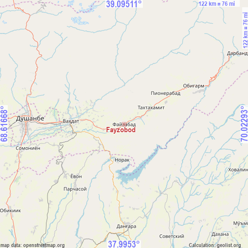
Fayzobod GPS coordinates[2]
38° 32' 50.316" North, 69° 19' 11.28" East
| Map corner | latitude | longitude |
|---|---|---|
| Upper-left | 39.09511°, | 68.61668° |
| Center: | 38.54731°, | 69.3198° |
| Lower-right: | 37.9953°, | 70.02293° |
| Map W x H: | 122.3×122.3 km | = 76×76mi |
| max Lat: | 40.99827° ⇑48.9% North |
| Fayzobod: | 38.54731° |
| min Lat: | ⇓51.1% South 36.72484° |
| min Long | Fayzobod | max Long |
| 67.60931° | 69.3198° | 73.96674° |
| W 44.3%⇐ | ⇒55.7% E |
Elevation
Elevation of Fayzobod is 1212 m = 3976 ft, and this is 249.5 m = 819 ft above average elevation for this country.
| Max E: |
3607 m = 11834 ft | 34.1% |
| Fayzobod | 1212 m 3976 ft | |
| Avg. | 962.5 m = 3158 ft | |
Min E: |
324 m = 1063 ft | 65.9% |
See also: Tajikistan elevation on elevation.city.
Geographical zone
Fayzobod is located in North temperate zone (between Tropic of Cancer and the Arctic Circle). Distance of this Northern Tropic circle is 1680.1 km =1044 mi to South.| Distance of | km | miles | from Fayzobod |
|---|---|---|---|
| North Pole | 5721 | 3554.9 | to North |
| Arctic Circle | 3115.1 | 1935.6 | to North |
| Tropic Cancer | 1680.1 | 1044 | to South |
| Equator | 4286.1 | 2663.3 | to South |


Nearby cities:
15 places around Fayzobod: (largest is in red/bold)
• Baljuvon
40.9 km =25.4 mi,  130°
130°
• Boshkengash
45.7 km =28.4 mi,  258°
258°
• Danghara
50.2 km =31.2 mi,  177°
177°
• Dushanbe
47 km =29.2 mi,  268°
268°
• Khovaling
61.5 km =38.2 mi,  111°
111°
• Norak
17.6 km =10.9 mi, 179°
• Obigarm
38.7 km =24 mi,  60°
60°
• Roghun
39.7 km =24.7 mi,  65°
65°
• Roghun
54.5 km =33.9 mi, 61°
• Somoniyon
48.9 km =30.4 mi, 256°
• Sovet
60.4 km =37.5 mi,  157°
157°
• Tagob
48.8 km =30.3 mi,  311°
311°
• Vahdat
26.6 km =16.5 mi, 272°
• Varzob
50.3 km =31.3 mi,  300°
300°
• Yovon
35.7 km =22.2 mi,  223°
223°
Sources, notices
• [Note1] Compared only with cities in Tajikistan existing in our database
• [Src1] Map data: © OpenStreetMap contributors (CC-BY-SA)
• [Src2] Other city data from geonames.org with taken over terms of usage.
• [Src3] Geographical zone / Annual Mean Temperature by Robert A. Rohde @ Wikipedia
