Dushanbe geodata
Dushanbe is a capital of a political entity; located in Tajikistan in Asia/Dushanbe (GMT+5) time zone. With population of 679,400 people, there are 0 cities with bigger population in this country. Compared to other cities in Tajikistan, 50% of cities are located further ↓South; 78.4% of cities are located further →East and 50% of cities have lower elevation than Dushanbe. Note1


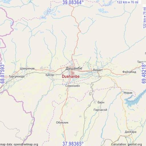
Dushanbe GPS coordinates[2]
38° 32' 8.7" North, 68° 46' 44.58" East
| Map corner | latitude | longitude |
|---|---|---|
| Upper-left | 39.08364°, | 68.07593° |
| Center: | 38.53575°, | 68.77905° |
| Lower-right: | 37.98365°, | 69.48218° |
| Map W x H: | 122.3×122.3 km | = 76×76mi |
| max Lat: | 40.99827° ⇑50% North |
| Dushanbe: | 38.53575° |
| min Lat: | ⇓50% South 36.72484° |
| min Long | Dushanbe | max Long |
| 67.60931° | 68.77905° | 73.96674° |
| W 21.6%⇐ | ⇒78.4% E |
Elevation
Elevation of Dushanbe is 767 m = 2516 ft, and this is 195.5 m = 641 ft below average elevation for this country.
| Max E: |
3607 m = 11834 ft | 50% |
| Avg. | 962.5 m = 3158 ft | |
| Dushanbe | 767 m = 2516 ft | |
Min E: |
324 m = 1063 ft | 50% |
See also: Dushanbe elevation on elevation.city.
Geographical zone
Dushanbe is located in North temperate zone (between Tropic of Cancer and the Arctic Circle). Distance of this Northern Tropic circle is 1678.9 km =1043.2 mi to South.| Distance of | km | miles | from Dushanbe |
|---|---|---|---|
| North Pole | 5722.3 | 3555.7 | to North |
| Arctic Circle | 3116.4 | 1936.4 | to North |
| Tropic Cancer | 1678.9 | 1043.2 | to South |
| Equator | 4284.8 | 2662.5 | to South |


Nearby cities:
15 places around Dushanbe: (largest is in red/bold)
• Abdurahmoni Jomí
65.6 km =40.8 mi,  177°
177°
• Boshkengash
8.1 km =5 mi,  163°
163°
• Danghara
69.2 km =43 mi,  134°
134°
• Fayzobod
47 km =29.2 mi,  88°
88°
• Hisor
19.9 km =12.4 mi,  266°
266°
• Khodzha-Maston
26.7 km =16.6 mi,  330°
330°
• Norak
50.1 km =31.1 mi,  108°
108°
• Obikiik
42.9 km =26.7 mi,  193°
193°
• Shahrinav
38.8 km =24.1 mi,  275°
275°
• Somoniyon
10.5 km =6.5 mi, 182°
• Tagob
35.2 km =21.9 mi,  17°
17°
• Tursunzoda
47.7 km =29.6 mi, 266°
• Vahdat
20.5 km =12.7 mi,  83°
83°
• Varzob
26.7 km =16.6 mi,  7°
7°
• Yovon
33.4 km =20.8 mi,  137°
137°
In other languages:
- In France: Douchanbé
- In German: Duschanbe
- In Italian: Dušhanbe
- In Russian: Душанбе
- In Chinese: 杜尚别
Sources, notices
• [Note1] Compared only with cities in Tajikistan existing in our database
• [Src1] Map data: © OpenStreetMap contributors (CC-BY-SA)
• [Src2] Other city data from geonames.org with taken over terms of usage.
• [Src3] Geographical zone / Annual Mean Temperature by Robert A. Rohde @ Wikipedia
