Boshkengash geodata
Boshkengash (Dushanbe) is a populated place; located in Tajikistan in Asia/Dushanbe (GMT+5) time zone. With population of 23,696 people, there are 13 cities with bigger population in this country. Compared to other cities in Tajikistan, 53.4% of cities are located further ↑North; 75% of cities are located further →East and 51.1% of cities have higher elevation than Boshkengash. Note1


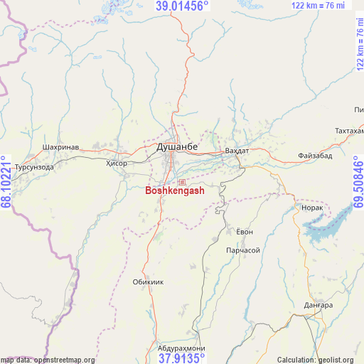
Boshkengash GPS coordinates[2]
38° 27' 58.068" North, 68° 48' 19.188" East
| Map corner | latitude | longitude |
|---|---|---|
| Upper-left | 39.01456°, | 68.10221° |
| Center: | 38.46613°, | 68.80533° |
| Lower-right: | 37.9135°, | 69.50846° |
| Map W x H: | 122.4×122.4 km | = 76.1×76.1mi |
| max Lat: | 40.99827° ⇑53.4% North |
| Boshkengash: | 38.46613° |
| min Lat: | ⇓46.6% South 36.72484° |
| min Long | Boshkengash | max Long |
| 67.60931° | 68.80533° | 73.96674° |
| W 25%⇐ | ⇒75% E |
Elevation
Elevation of Boshkengash is 755 m = 2477 ft, and this is 207.5 m = 681 ft below average elevation for this country.
| Max E: |
3607 m = 11834 ft | 51.1% |
| Avg. | 962.5 m = 3158 ft | |
| Boshkengash | 755 m = 2477 ft | |
Min E: |
324 m = 1063 ft | 48.9% |
See also: Tajikistan elevation on elevation.city.
Geographical zone
Boshkengash is located in North temperate zone (between Tropic of Cancer and the Arctic Circle). Distance of this Northern Tropic circle is 1671.1 km =1038.4 mi to South.| Distance of | km | miles | from Boshkengash |
|---|---|---|---|
| North Pole | 5730 | 3560.5 | to North |
| Arctic Circle | 3124.1 | 1941.2 | to North |
| Tropic Cancer | 1671.1 | 1038.4 | to South |
| Equator | 4277 | 2657.6 | to South |


Nearby cities:
15 places around Boshkengash: (largest is in red/bold)
• Abdurahmoni Jomí
57.8 km =35.9 mi,  179°
179°
• Danghara
62.2 km =38.6 mi,  131°
131°
• Dushanbe
8.1 km =5 mi,  343°
343°
• Fayzobod
45.7 km =28.4 mi,  78°
78°
• Hisor
23.1 km =14.4 mi,  286°
286°
• Khodzha-Maston
34.6 km =21.5 mi,  333°
333°
• Norak
45.9 km =28.5 mi,  100°
100°
• Obikiik
36.1 km =22.4 mi,  199°
199°
• Shahrinav
42.5 km =26.4 mi, 285°
• Somoniyon
3.8 km =2.4 mi,  224°
224°
• Tagob
42.2 km =26.2 mi,  11°
11°
• Tursunzoda
50.2 km =31.2 mi,  275°
275°
• Vahdat
20.7 km =12.9 mi,  61°
61°
• Varzob
34.2 km =21.3 mi,  1°
1°
• Yovon
26.4 km =16.4 mi, 129°
Sources, notices
• [Note1] Compared only with cities in Tajikistan existing in our database
• [Src1] Map data: © OpenStreetMap contributors (CC-BY-SA)
• [Src2] Other city data from geonames.org with taken over terms of usage.
• [Src3] Geographical zone / Annual Mean Temperature by Robert A. Rohde @ Wikipedia
