Shahrinav geodata
Shahrinav (Republican Subordination) is a seat of a second-order administrative division; located in Tajikistan in Asia/Dushanbe (GMT+5) time zone. With population of 5,385 people, there are 46 cities with bigger population in this country. Compared to other cities in Tajikistan, 53.4% of cities are located further ↓South; 92% of cities are located further →East and 54.5% of cities have lower elevation than Shahrinav. Note1


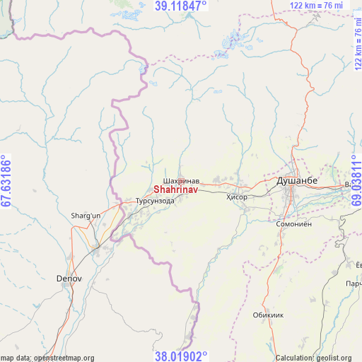
Shahrinav GPS coordinates[2]
38° 34' 15.06" North, 68° 20' 5.928" East
| Map corner | latitude | longitude |
|---|---|---|
| Upper-left | 39.11847°, | 67.63186° |
| Center: | 38.57085°, | 68.33498° |
| Lower-right: | 38.01902°, | 69.03811° |
| Map W x H: | 122.2×122.2 km | = 75.9×75.9mi |
| max Lat: | 40.99827° ⇑46.6% North |
| Shahrinav: | 38.57085° |
| min Lat: | ⇓53.4% South 36.72484° |
| min Long | Shahrinav | max Long |
| 67.60931° | 68.33498° | 73.96674° |
| W 8%⇐ | ⇒92% E |
Elevation
Elevation of Shahrinav is 850 m = 2789 ft, and this is 112.5 m = 369 ft below average elevation for this country.
| Max E: |
3607 m = 11834 ft | 45.5% |
| Avg. | 962.5 m = 3158 ft | |
| Shahrinav | 850 m = 2789 ft | |
Min E: |
324 m = 1063 ft | 54.5% |
See also: Tajikistan elevation on elevation.city.
Geographical zone
Shahrinav is located in North temperate zone (between Tropic of Cancer and the Arctic Circle). Distance of this Northern Tropic circle is 1682.8 km =1045.6 mi to South.| Distance of | km | miles | from Shahrinav |
|---|---|---|---|
| North Pole | 5718.4 | 3553.2 | to North |
| Arctic Circle | 3112.5 | 1934 | to North |
| Tropic Cancer | 1682.8 | 1045.6 | to South |
| Equator | 4288.7 | 2664.9 | to South |


Nearby cities:
15 places around Shahrinav: (largest is in red/bold)
• Abdurahmoni Jomí
80.8 km =50.2 mi,  149°
149°
• Boshkengash
42.5 km =26.4 mi,  105°
105°
• Dushanbe
38.8 km =24.1 mi,  95°
95°
• Fayzobod
85.7 km =53.3 mi,  91°
91°
• Hisor
19.5 km =12.1 mi, 105°
• Khodzha-Maston
31.9 km =19.8 mi,  52°
52°
• Norak
88.3 km =54.9 mi, 103°
• Obikiik
54 km =33.6 mi, 147°
• Qŭrghonteppa
90.8 km =56.4 mi, 154°
• Somoniyon
40.9 km =25.4 mi, 110°
• Tagob
57.2 km =35.5 mi,  58°
58°
• Tursunzoda
11.1 km =6.9 mi,  234°
234°
• Vahdat
59 km =36.7 mi, 91°
• Varzob
47.6 km =29.6 mi, 61°
• Yovon
67.5 km =41.9 mi,  115°
115°
Sources, notices
• [Note1] Compared only with cities in Tajikistan existing in our database
• [Src1] Map data: © OpenStreetMap contributors (CC-BY-SA)
• [Src2] Other city data from geonames.org with taken over terms of usage.
• [Src3] Geographical zone / Annual Mean Temperature by Robert A. Rohde @ Wikipedia
