Vahdat geodata
Vahdat (Republican Subordination) is a seat of a second-order administrative division; located in Tajikistan in Asia/Dushanbe (GMT+5) time zone. With population of 45,693 people, there are 6 cities with bigger population in this country. Compared to other cities in Tajikistan, 52.3% of cities are located further ↓South; 61.4% of cities are located further →East and 56.8% of cities have lower elevation than Vahdat. Note1


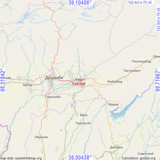
Vahdat GPS coordinates[2]
38° 33' 22.752" North, 69° 0' 48.744" East
| Map corner | latitude | longitude |
|---|---|---|
| Upper-left | 39.10406°, | 68.31042° |
| Center: | 38.55632°, | 69.01354° |
| Lower-right: | 38.00438°, | 69.71667° |
| Map W x H: | 122.3×122.3 km | = 76×76mi |
| max Lat: | 40.99827° ⇑47.7% North |
| Vahdat: | 38.55632° |
| min Lat: | ⇓52.3% South 36.72484° |
| min Long | Vahdat | max Long |
| 67.60931° | 69.01354° | 73.96674° |
| W 38.6%⇐ | ⇒61.4% E |
Elevation
Elevation of Vahdat is 872 m = 2861 ft, and this is 90.5 m = 297 ft below average elevation for this country.
| Max E: |
3607 m = 11834 ft | 43.2% |
| Avg. | 962.5 m = 3158 ft | |
| Vahdat | 872 m = 2861 ft | |
Min E: |
324 m = 1063 ft | 56.8% |
See also: Vahdat elevation on elevation.city.
Geographical zone
Vahdat is located in North temperate zone (between Tropic of Cancer and the Arctic Circle). Distance of this Northern Tropic circle is 1681.1 km =1044.6 mi to South.| Distance of | km | miles | from Vahdat |
|---|---|---|---|
| North Pole | 5720 | 3554.2 | to North |
| Arctic Circle | 3114.1 | 1935 | to North |
| Tropic Cancer | 1681.1 | 1044.6 | to South |
| Equator | 4287.1 | 2663.9 | to South |


Nearby cities:
15 places around Vahdat: (largest is in red/bold)
• Baljuvon
64 km =39.8 mi,  115°
115°
• Boshkengash
20.7 km =12.9 mi,  241°
241°
• Danghara
58.6 km =36.4 mi,  150°
150°
• Dushanbe
20.5 km =12.7 mi,  263°
263°
• Fayzobod
26.6 km =16.5 mi,  92°
92°
• Hisor
40.4 km =25.1 mi,  265°
265°
• Khodzha-Maston
39.6 km =24.6 mi,  301°
301°
• Norak
32.7 km =20.3 mi, 124°
• Obigarm
63 km =39.1 mi,  73°
73°
• Obikiik
53.4 km =33.2 mi,  214°
214°
• Shahrinav
59 km =36.7 mi, 271°
• Somoniyon
24.4 km =15.2 mi, 238°
• Tagob
32.9 km =20.4 mi,  342°
342°
• Varzob
29.5 km =18.3 mi,  324°
324°
• Yovon
27 km =16.8 mi,  175°
175°
Sources, notices
• [Note1] Compared only with cities in Tajikistan existing in our database
• [Src1] Map data: © OpenStreetMap contributors (CC-BY-SA)
• [Src2] Other city data from geonames.org with taken over terms of usage.
• [Src3] Geographical zone / Annual Mean Temperature by Robert A. Rohde @ Wikipedia
