Ashgabat geodata
Ashgabat is a capital of a political entity; located in Turkmenistan in Asia/Ashgabat (GMT+5) time zone. With population of 727,700 people, there are 0 cities with bigger population in this country. Compared to other cities in Turkmenistan, 63.3% of cities are located further ↑North; 70% of cities are located further →East and 60% of cities have lower elevation than Ashgabat. Note1


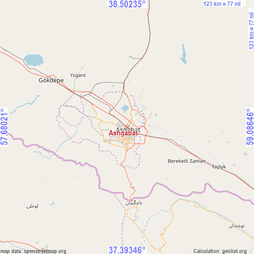
Ashgabat GPS coordinates[2]
37° 57' 0" North, 58° 22' 59.988" East
| Map corner | latitude | longitude |
|---|---|---|
| Upper-left | 38.50235°, | 57.68021° |
| Center: | 37.95°, | 58.38333° |
| Lower-right: | 37.39346°, | 59.08646° |
| Map W x H: | 123.3×123.3 km | = 76.6×76.6mi |
| max Lat: | 42.32773° ⇑63.3% North |
| Ashgabat: | 37.95° |
| min Lat: | ⇓36.7% South 35.27992° |
| min Long | Ashgabat | max Long |
| 52.95517° | 58.38333° | 66.04656° |
| W 30%⇐ | ⇒70% E |
Elevation
Elevation of Ashgabat is 219 m = 719 ft, and this is 22.6 m = 74 ft above average elevation for this country.
| Max E: |
649 m = 2129 ft | 40% |
| Ashgabat | 219 m 719 ft | |
| Avg. | 196.4 m = 644 ft | |
Min E: |
5 m = 16 ft | 60% |
See also: Ashgabat elevation on elevation.city.
Geographical zone
Ashgabat is located in North temperate zone (between Tropic of Cancer and the Arctic Circle). Distance of this Northern Tropic circle is 1613.7 km =1002.7 mi to South.| Distance of | km | miles | from Ashgabat |
|---|---|---|---|
| North Pole | 5787.4 | 3596.1 | to North |
| Arctic Circle | 3181.5 | 1976.9 | to North |
| Tropic Cancer | 1613.7 | 1002.7 | to South |
| Equator | 4219.6 | 2621.9 | to South |


Nearby cities:
13 places around Ashgabat: (largest is in red/bold)
• Abadan
20 km =12.4 mi,  305°
305°
• Annau
13.5 km =8.4 mi,  120°
120°
• Arçabil
26 km =16.2 mi,  261°
261°
• Baharly
99.2 km =61.6 mi,  303°
303°
• Bayramaly
334.5 km =207.8 mi,  96°
96°
• Bereket
287.8 km =178.8 mi, 300°
• Gumdag
358 km =222.5 mi,  292°
292°
• Kaka
127.4 km =79.2 mi, 121°
• Magtymguly
191.6 km =119.1 mi, 286°
• Mary
305.5 km =189.8 mi, 97°
• Murgab
319.5 km =198.5 mi, 99°
• Serdar
216.1 km =134.3 mi, 301°
• Tejen
197.1 km =122.5 mi,  108°
108°
In other languages:
- In Spanish: Asjabad
- In France: Achgabat
- In German: Aschgabat
- In Italian: Aşgabat
- In Russian: Ашхабад
- In Chinese: 阿什哈巴德
Sources, notices
• [Note1] Compared only with cities in Turkmenistan existing in our database
• [Src1] Map data: © OpenStreetMap contributors (CC-BY-SA)
• [Src2] Other city data from geonames.org with taken over terms of usage.
• [Src3] Geographical zone / Annual Mean Temperature by Robert A. Rohde @ Wikipedia
