Oued Meliz geodata
Oued Meliz (Jundūbah) is a populated place; located in Tunisia in Africa/Tunis (GMT+1) time zone. With population of 2,148 people, there are 141 cities with bigger population in this country. Compared to other cities in Tunisia, 67.8% of cities are located further ↓South; 93.7% of cities are located further →East and 74.1% of cities have lower elevation than Oued Meliz. Note1


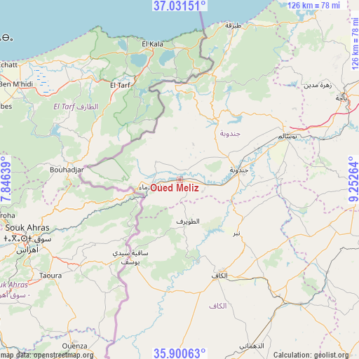
Oued Meliz GPS coordinates[2]
36° 28' 5.268" North, 8° 32' 58.236" East
| Map corner | latitude | longitude |
|---|---|---|
| Upper-left | 37.03151°, | 7.84639° |
| Center: | 36.46813°, | 8.54951° |
| Lower-right: | 35.90063°, | 9.25264° |
| Map W x H: | 125.7×125.7 km | = 78.1×78.1mi |
| max Lat: | 37.27442° ⇑32.2% North |
| Oued Meliz: | 36.46813° |
| min Lat: | ⇓67.8% South 32.31662° |
| min Long | Oued Meliz | max Long |
| 7.87765° | 8.54951° | 11.21965° |
| W 6.3%⇐ | ⇒93.7% E |
Elevation
Elevation of Oued Meliz is 175 m = 574 ft, and this is 25.6 m = 84 ft above average elevation for this country.
| Max E: |
999 m = 3278 ft | 25.9% |
| Oued Meliz | 175 m 574 ft | |
| Avg. | 149.4 m = 490 ft | |
Min E: |
-6 m = -20 ft | 74.1% |
See also: Tunisia elevation on elevation.city.
Geographical zone
Oued Meliz is located in North temperate zone (between Tropic of Cancer and the Arctic Circle). Distance of this Northern Tropic circle is 1449 km =900.4 mi to South.| Distance of | km | miles | from Oued Meliz |
|---|---|---|---|
| North Pole | 5952.2 | 3698.5 | to North |
| Arctic Circle | 3346.3 | 2079.3 | to North |
| Tropic Cancer | 1449 | 900.4 | to South |
| Equator | 4054.9 | 2519.6 | to South |


Nearby cities:
15 places around Oued Meliz: (largest is in red/bold)
• As Sars
60.7 km =37.7 mi,  135°
135°
• Béja
63.3 km =39.3 mi,  63°
63°
• El Kef
35.5 km =22.1 mi,  156°
156°
• El Ksour
70.4 km =43.7 mi,  154°
154°
• Fernana
24.6 km =15.3 mi,  32°
32°
• Gafour
71.3 km =44.3 mi,  103°
103°
• Jendouba
21 km =13 mi,  79°
79°
• Le Krib
54.8 km =34.1 mi,  106°
106°
• Menzel Salem
68.3 km =42.4 mi,  185°
185°
• Nibbar
27.4 km =17 mi,  134°
134°
• Sakiet Sidi Youssef
32.3 km =20.1 mi,  212°
212°
• Tabarka
57.2 km =35.5 mi,  18°
18°
• Tabursuq
62.4 km =38.8 mi,  91°
91°
• Tajerouine
64.1 km =39.8 mi,  179°
179°
• Testour
80.4 km =50 mi, 83°
Sources, notices
• [Note1] Compared only with cities in Tunisia existing in our database
• [Src1] Map data: © OpenStreetMap contributors (CC-BY-SA)
• [Src2] Other city data from geonames.org with taken over terms of usage.
• [Src3] Geographical zone / Annual Mean Temperature by Robert A. Rohde @ Wikipedia
