Le Krib geodata
Le Krib (Silyānah) is a populated place; located in Tunisia in Africa/Tunis (GMT+1) time zone. With population of 7,691 people, there are 96 cities with bigger population in this country. Compared to other cities in Tunisia, 60.8% of cities are located further ↓South; 81.1% of cities are located further →East and 89.5% of cities have lower elevation than Le Krib. Note1


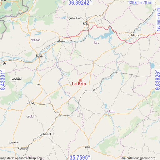
Le Krib GPS coordinates[2]
36° 19' 40.872" North, 9° 8' 10.068" East
| Map corner | latitude | longitude |
|---|---|---|
| Upper-left | 36.89242°, | 8.43301° |
| Center: | 36.32802°, | 9.13613° |
| Lower-right: | 35.7595°, | 9.83926° |
| Map W x H: | 126×126 km | = 78.3×78.3mi |
| max Lat: | 37.27442° ⇑39.2% North |
| Le Krib: | 36.32802° |
| min Lat: | ⇓60.8% South 32.31662° |
| min Long | Le Krib | max Long |
| 7.87765° | 9.13613° | 11.21965° |
| W 18.9%⇐ | ⇒81.1% E |
Elevation
Elevation of Le Krib is 481 m = 1578 ft, and this is 331.6 m = 1088 ft above average elevation for this country.
| Max E: |
999 m = 3278 ft | 10.5% |
| Le Krib | 481 m 1578 ft | |
| Avg. | 149.4 m = 490 ft | |
Min E: |
-6 m = -20 ft | 89.5% |
See also: Tunisia elevation on elevation.city.
Geographical zone
Le Krib is located in North temperate zone (between Tropic of Cancer and the Arctic Circle). Distance of this Northern Tropic circle is 1433.4 km =890.7 mi to South.| Distance of | km | miles | from Le Krib |
|---|---|---|---|
| North Pole | 5967.8 | 3708.2 | to North |
| Arctic Circle | 3361.9 | 2089 | to North |
| Tropic Cancer | 1433.4 | 890.7 | to South |
| Equator | 4039.3 | 2509.9 | to South |


Nearby cities:
15 places around Le Krib: (largest is in red/bold)
• As Sars
29.8 km =18.5 mi,  200°
200°
• Bou Arada
43.6 km =27.1 mi,  86°
86°
• Béja
44.4 km =27.6 mi,  5°
5°
• El Kef
42.3 km =26.3 mi,  246°
246°
• El Ksour
53.1 km =33 mi,  205°
205°
• Fernana
53.6 km =33.3 mi,  312°
312°
• Gafour
16.9 km =10.5 mi, 92°
• Goubellat
52.8 km =32.8 mi,  63°
63°
• Jendouba
37.2 km =23.1 mi,  301°
301°
• Maktar
52.6 km =32.7 mi,  173°
173°
• Nibbar
33.3 km =20.7 mi,  263°
263°
• Oued Meliz
54.8 km =34.1 mi,  286°
286°
• Siliana
34.3 km =21.3 mi,  142°
142°
• Tabursuq
17.5 km =10.9 mi,  34°
34°
• Testour
37 km =23 mi,  47°
47°
Sources, notices
• [Note1] Compared only with cities in Tunisia existing in our database
• [Src1] Map data: © OpenStreetMap contributors (CC-BY-SA)
• [Src2] Other city data from geonames.org with taken over terms of usage.
• [Src3] Geographical zone / Annual Mean Temperature by Robert A. Rohde @ Wikipedia
