Nibbar geodata
Nibbar (Kef) is a populated place; located in Tunisia in Africa/Tunis (GMT+1) time zone. With population of 3,393 people, there are 132 cities with bigger population in this country. Compared to other cities in Tunisia, 59.4% of cities are located further ↓South; 89.5% of cities are located further →East and 86.7% of cities have lower elevation than Nibbar. Note1


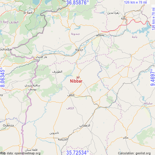
Nibbar GPS coordinates[2]
36° 17' 38.796" North, 8° 45' 59.652" East
| Map corner | latitude | longitude |
|---|---|---|
| Upper-left | 36.85876°, | 8.06345° |
| Center: | 36.29411°, | 8.76657° |
| Lower-right: | 35.72534°, | 9.4697° |
| Map W x H: | 126×126 km | = 78.3×78.3mi |
| max Lat: | 37.27442° ⇑40.6% North |
| Nibbar: | 36.29411° |
| min Lat: | ⇓59.4% South 32.31662° |
| min Long | Nibbar | max Long |
| 7.87765° | 8.76657° | 11.21965° |
| W 10.5%⇐ | ⇒89.5% E |
Elevation
Elevation of Nibbar is 405 m = 1329 ft, and this is 255.6 m = 839 ft above average elevation for this country.
| Max E: |
999 m = 3278 ft | 13.3% |
| Nibbar | 405 m 1329 ft | |
| Avg. | 149.4 m = 490 ft | |
Min E: |
-6 m = -20 ft | 86.7% |
See also: Tunisia elevation on elevation.city.
Geographical zone
Nibbar is located in North temperate zone (between Tropic of Cancer and the Arctic Circle). Distance of this Northern Tropic circle is 1429.6 km =888.3 mi to South.| Distance of | km | miles | from Nibbar |
|---|---|---|---|
| North Pole | 5971.5 | 3710.5 | to North |
| Arctic Circle | 3365.6 | 2091.3 | to North |
| Tropic Cancer | 1429.6 | 888.3 | to South |
| Equator | 4035.5 | 2507.5 | to South |


Nearby cities:
15 places around Nibbar: (largest is in red/bold)
• As Sars
33.3 km =20.7 mi,  136°
136°
• Béja
60.7 km =37.7 mi,  37°
37°
• El Kef
14.4 km =8.9 mi,  202°
202°
• El Ksour
45.5 km =28.3 mi,  166°
166°
• Fernana
40.7 km =25.3 mi,  351°
351°
• Gafour
50.1 km =31.1 mi,  86°
86°
• Jendouba
23.1 km =14.4 mi,  3°
3°
• Le Krib
33.3 km =20.7 mi,  83°
83°
• Maktar
62.2 km =38.6 mi, 141°
• Menzel Salem
55.2 km =34.3 mi,  208°
208°
• Oued Meliz
27.4 km =17 mi,  314°
314°
• Sakiet Sidi Youssef
37.7 km =23.4 mi,  257°
257°
• Siliana
59 km =36.7 mi,  113°
113°
• Tabursuq
46.7 km =29 mi,  67°
67°
• Tajerouine
48.7 km =30.3 mi, 203°
Sources, notices
• [Note1] Compared only with cities in Tunisia existing in our database
• [Src1] Map data: © OpenStreetMap contributors (CC-BY-SA)
• [Src2] Other city data from geonames.org with taken over terms of usage.
• [Src3] Geographical zone / Annual Mean Temperature by Robert A. Rohde @ Wikipedia
