Tabarka geodata
Tabarka (Jundūbah) is a populated place; located in Tunisia in Africa/Tunis (GMT+1) time zone. With population of 13,712 people, there are 76 cities with bigger population in this country. Compared to other cities in Tunisia, 90.2% of cities are located further ↓South; 90.2% of cities are located further →East and 99.3% of cities have higher elevation than Tabarka. Note1


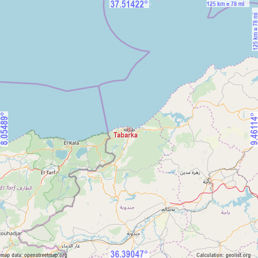
Tabarka GPS coordinates[2]
36° 57' 15.912" North, 8° 45' 28.836" East
| Map corner | latitude | longitude |
|---|---|---|
| Upper-left | 37.51422°, | 8.05489° |
| Center: | 36.95442°, | 8.75801° |
| Lower-right: | 36.39047°, | 9.46114° |
| Map W x H: | 124.9×124.9 km | = 77.6×77.6mi |
| max Lat: | 37.27442° ⇑9.8% North |
| Tabarka: | 36.95442° |
| min Lat: | ⇓90.2% South 32.31662° |
| min Long | Tabarka | max Long |
| 7.87765° | 8.75801° | 11.21965° |
| W 9.8%⇐ | ⇒90.2% E |
Elevation
Elevation of Tabarka is 2 m = 7 ft, and this is 147.4 m = 484 ft below average elevation for this country.
| Max E: |
999 m = 3278 ft | 99.3% |
| Avg. | 149.4 m = 490 ft | |
| Tabarka | 2 m = 7 ft | |
Min E: |
-6 m = -20 ft | 0.7% |
See also: Tunisia elevation on elevation.city.
Geographical zone
Tabarka is located in North temperate zone (between Tropic of Cancer and the Arctic Circle). Distance of this Northern Tropic circle is 1503 km =933.9 mi to South.| Distance of | km | miles | from Tabarka |
|---|---|---|---|
| North Pole | 5898.1 | 3664.9 | to North |
| Arctic Circle | 3292.2 | 2045.7 | to North |
| Tropic Cancer | 1503 | 933.9 | to South |
| Equator | 4108.9 | 2553.2 | to South |


Nearby cities:
15 places around Tabarka: (largest is in red/bold)
• Béja
45.5 km =28.3 mi,  124°
124°
• Douar Tindja
91.1 km =56.6 mi,  74°
74°
• El Kef
86.9 km =54 mi,  183°
183°
• Fernana
33.7 km =20.9 mi,  189°
189°
• Gafour
86.7 km =53.9 mi,  144°
144°
• Jendouba
50.4 km =31.3 mi, 177°
• Le Krib
77.4 km =48.1 mi,  154°
154°
• Mateur
81.2 km =50.5 mi,  83°
83°
• Medjez el Bab
83.3 km =51.8 mi,  114°
114°
• Nibbar
73.4 km =45.6 mi, 179°
• Oued Meliz
57.2 km =35.5 mi,  198°
198°
• Sakiet Sidi Youssef
88.9 km =55.2 mi, 203°
• Sejenane
44.1 km =27.4 mi, 74°
• Tabursuq
70.5 km =43.8 mi, 141°
• Testour
75.7 km =47 mi,  126°
126°
Sources, notices
• [Note1] Compared only with cities in Tunisia existing in our database
• [Src1] Map data: © OpenStreetMap contributors (CC-BY-SA)
• [Src2] Other city data from geonames.org with taken over terms of usage.
• [Src3] Geographical zone / Annual Mean Temperature by Robert A. Rohde @ Wikipedia
