Jendouba geodata
Jendouba (Jundūbah) is a seat of a first-order administrative division; located in Tunisia in Africa/Tunis (GMT+1) time zone. With population of 51,408 people, there are 25 cities with bigger population in this country. Compared to other cities in Tunisia, 69.2% of cities are located further ↓South; 88.8% of cities are located further →East and 72% of cities have lower elevation than Jendouba. Note1


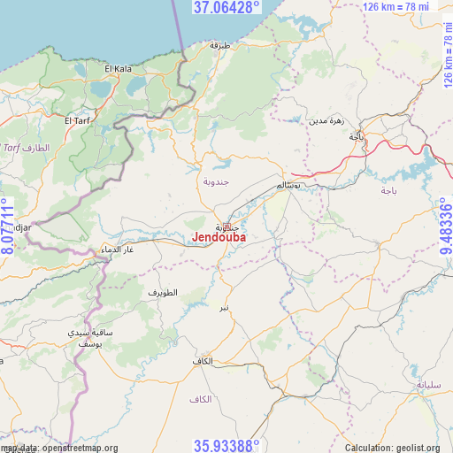
Jendouba GPS coordinates[2]
36° 30' 4.104" North, 8° 46' 48.864" East
| Map corner | latitude | longitude |
|---|---|---|
| Upper-left | 37.06428°, | 8.07711° |
| Center: | 36.50114°, | 8.78024° |
| Lower-right: | 35.93388°, | 9.48336° |
| Map W x H: | 125.7×125.7 km | = 78.1×78.1mi |
| max Lat: | 37.27442° ⇑30.8% North |
| Jendouba: | 36.50114° |
| min Lat: | ⇓69.2% South 32.31662° |
| min Long | Jendouba | max Long |
| 7.87765° | 8.78024° | 11.21965° |
| W 11.2%⇐ | ⇒88.8% E |
Elevation
Elevation of Jendouba is 143 m = 469 ft, and this is 6.4 m = 21 ft below average elevation for this country.
| Max E: |
999 m = 3278 ft | 28% |
| Avg. | 149.4 m = 490 ft | |
| Jendouba | 143 m = 469 ft | |
Min E: |
-6 m = -20 ft | 72% |
See also: Jendouba elevation on elevation.city.
Geographical zone
Jendouba is located in North temperate zone (between Tropic of Cancer and the Arctic Circle). Distance of this Northern Tropic circle is 1452.6 km =902.6 mi to South.| Distance of | km | miles | from Jendouba |
|---|---|---|---|
| North Pole | 5948.5 | 3696.2 | to North |
| Arctic Circle | 3342.6 | 2077 | to North |
| Tropic Cancer | 1452.6 | 902.6 | to South |
| Equator | 4058.5 | 2521.8 | to South |


Nearby cities:
15 places around Jendouba: (largest is in red/bold)
• As Sars
51.9 km =32.2 mi,  155°
155°
• Béja
43.7 km =27.2 mi,  55°
55°
• El Kef
37 km =23 mi,  190°
190°
• El Ksour
67.9 km =42.2 mi,  172°
172°
• Fernana
18.7 km =11.6 mi,  336°
336°
• Gafour
52.7 km =32.7 mi,  112°
112°
• Le Krib
37.2 km =23.1 mi,  121°
121°
• Nibbar
23.1 km =14.4 mi,  183°
183°
• Oued Meliz
21 km =13 mi,  259°
259°
• Sakiet Sidi Youssef
49 km =30.4 mi,  230°
230°
• Siliana
70.3 km =43.7 mi,  131°
131°
• Tabarka
50.4 km =31.3 mi,  357°
357°
• Tabursuq
42.1 km =26.2 mi,  96°
96°
• Tajerouine
70.8 km =44 mi,  196°
196°
• Testour
59.5 km =37 mi,  84°
84°
Sources, notices
• [Note1] Compared only with cities in Tunisia existing in our database
• [Src1] Map data: © OpenStreetMap contributors (CC-BY-SA)
• [Src2] Other city data from geonames.org with taken over terms of usage.
• [Src3] Geographical zone / Annual Mean Temperature by Robert A. Rohde @ Wikipedia
