Zarzis geodata
Zarzis (Madanīn) is a populated place; located in Tunisia in Africa/Tunis (GMT+1) time zone. With population of 79,316 people, there are 10 cities with bigger population in this country. Compared to other cities in Tunisia, 95.1% of cities are located further ↑North; 98.6% of cities are located further ←West and 82.5% of cities have higher elevation than Zarzis. Note1


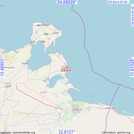
Zarzis GPS coordinates[2]
33° 30' 14.328" North, 11° 6' 43.74" East
| Map corner | latitude | longitude |
|---|---|---|
| Upper-left | 34.08829°, | 10.40903° |
| Center: | 33.50398°, | 11.11215° |
| Lower-right: | 32.9157°, | 11.81528° |
| Map W x H: | 130.4×130.4 km | = 81×81mi |
| max Lat: | 37.27442° ⇑95.1% North |
| Zarzis: | 33.50398° |
| min Lat: | ⇓4.9% South 32.31662° |
| min Long | Zarzis | max Long |
| 7.87765° | 11.11215° | 11.21965° |
| W 98.6%⇐ | ⇒1.4% E |
Elevation
Elevation of Zarzis is 11 m = 36 ft, and this is 138.4 m = 454 ft below average elevation for this country.
| Max E: |
999 m = 3278 ft | 82.5% |
| Avg. | 149.4 m = 490 ft | |
| Zarzis | 11 m = 36 ft | |
Min E: |
-6 m = -20 ft | 17.5% |
See also: Zarzis elevation on elevation.city.
Geographical zone
Zarzis is located in North temperate zone (between Tropic of Cancer and the Arctic Circle). Distance of this Northern Tropic circle is 1119.4 km =695.6 mi to South.| Distance of | km | miles | from Zarzis |
|---|---|---|---|
| North Pole | 6281.8 | 3903.3 | to North |
| Arctic Circle | 3675.9 | 2284.1 | to North |
| Tropic Cancer | 1119.4 | 695.6 | to South |
| Equator | 3725.3 | 2314.8 | to South |


Nearby cities:
15 places around Zarzis: (largest is in red/bold)
• Ben Gardane
41.9 km =26 mi,  166°
166°
• Beni Kheddache
89.3 km =55.5 mi,  251°
251°
• Bou Attouche
130.4 km =81 mi,  289°
289°
• El Hamma
129.1 km =80.2 mi, 289°
• Erriadh
42.6 km =26.5 mi,  325°
325°
• Gabès
102.8 km =63.9 mi, 294°
• Gremda
141.8 km =88.1 mi,  347°
347°
• Houmt El Souk
47.6 km =29.6 mi, 330°
• Matmata
105.8 km =65.7 mi,  272°
272°
• Medenine
58.7 km =36.5 mi, 253°
• Midoun
35.6 km =22.1 mi,  341°
341°
• Remada
148 km =92 mi,  206°
206°
• Sfax
141.3 km =87.8 mi, 346°
• Skhira
130.6 km =81.2 mi,  312°
312°
• Tataouine
88.6 km =55.1 mi,  223°
223°
Sources, notices
• [Note1] Compared only with cities in Tunisia existing in our database
• [Src1] Map data: © OpenStreetMap contributors (CC-BY-SA)
• [Src2] Other city data from geonames.org with taken over terms of usage.
• [Src3] Geographical zone / Annual Mean Temperature by Robert A. Rohde @ Wikipedia
