Bayır geodata
Bayır (Muğla) is a populated place; located in Turkey in Europe/Istanbul (GMT+3) time zone. With population of 4,005 people, there are 778 cities with bigger population in this country. Compared to other cities in Turkey, 81.2% of cities are located further ↑North; 88.6% of cities are located further →East and 64.8% of cities have higher elevation than Bayır. Note1


Bayır GPS coordinates[2]
37° 16' 3.864" North, 28° 13' 0.372" East
| Map corner | latitude | longitude |
|---|---|---|
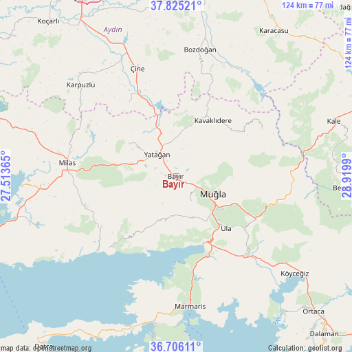
| Upper-left | 37.82521°, | 27.51365° |
| Center: | 37.26774°, | 28.21677° |
| Lower-right: | 36.70611°, | 28.9199° |
| Map W x H: | 124.4×124.4 km | = 77.3×77.3mi |
| max Lat: | 42.02683° ⇑81.2% North |
| Bayır: | 37.26774° |
| min Lat: | ⇓18.8% South 35.9025° |
| min Long | Bayır | max Long |
| 25.90902° | 28.21677° | 44.60099° |
| W 11.4%⇐ | ⇒88.6% E |
Elevation
Elevation of Bayır is 422 m = 1385 ft, and this is 295.4 m = 969 ft below average elevation for this country.
| Max E: |
2682 m = 8799 ft | 64.8% |
| Avg. | 717.4 m = 2354 ft | |
| Bayır | 422 m = 1385 ft | |
Min E: |
0 m = 0 ft | 35.2% |
See also: Turkey elevation on elevation.city.
Geographical zone
Bayır is located in North temperate zone (between Tropic of Cancer and the Arctic Circle). Distance of this Northern Tropic circle is 1537.9 km =955.6 mi to South.| Distance of | km | miles | from Bayır |
|---|---|---|---|
| North Pole | 5863.3 | 3643.3 | to North |
| Arctic Circle | 3257.4 | 2024.1 | to North |
| Tropic Cancer | 1537.9 | 955.6 | to South |
| Equator | 4143.8 | 2574.8 | to South |


Nearby cities:
15 places around Bayır: (largest is in red/bold)
• Akçaova
31.1 km =19.3 mi,  327°
327°
• Bozarmut
6.2 km =3.9 mi,  317°
317°
• Bozdoğan
45.7 km =28.4 mi,  10°
10°
• Göktepe
34.6 km =21.5 mi,  60°
60°
• Kavaklıdere
23.5 km =14.6 mi,  33°
33°
• Menteşe
17.4 km =10.8 mi,  165°
165°
• Milas
38.7 km =24 mi,  278°
278°
• Muğla
14.4 km =8.9 mi,  112°
112°
• Turgut
20.3 km =12.6 mi,  305°
305°
• Ula
25.3 km =15.7 mi,  135°
135°
• Yatağan
10.4 km =6.5 mi, 320°
• Yerkesik
15.8 km =9.8 mi,  157°
157°
• Yeşilyurt
9.8 km =6.1 mi,  147°
147°
• Çine
40.8 km =25.4 mi,  340°
340°
• Ören
33.9 km =21.1 mi,  220°
220°
Sources, notices
• [Note1] Compared only with cities in Turkey existing in our database
• [Src1] Map data: © OpenStreetMap contributors (CC-BY-SA)
• [Src2] Other city data from geonames.org with taken over terms of usage.
• [Src3] Geographical zone / Annual Mean Temperature by Robert A. Rohde @ Wikipedia
