Bozarmut geodata
Bozarmut (Muğla) is a populated place; located in Turkey in Europe/Istanbul (GMT+3) time zone. With population of 2,168 people, there are 925 cities with bigger population in this country. Compared to other cities in Turkey, 80.1% of cities are located further ↑North; 88.9% of cities are located further →East and 66.2% of cities have higher elevation than Bozarmut. Note1


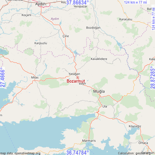
Bozarmut GPS coordinates[2]
37° 18' 33.012" North, 28° 10' 10.992" East
| Map corner | latitude | longitude |
|---|---|---|
| Upper-left | 37.86634°, | 27.4666° |
| Center: | 37.30917°, | 28.16972° |
| Lower-right: | 36.74784°, | 28.87285° |
| Map W x H: | 124.4×124.4 km | = 77.3×77.3mi |
| max Lat: | 42.02683° ⇑80.1% North |
| Bozarmut: | 37.30917° |
| min Lat: | ⇓19.9% South 35.9025° |
| min Long | Bozarmut | max Long |
| 25.90902° | 28.16972° | 44.60099° |
| W 11.1%⇐ | ⇒88.9% E |
Elevation
Elevation of Bozarmut is 386 m = 1266 ft, and this is 331.4 m = 1087 ft below average elevation for this country.
| Max E: |
2682 m = 8799 ft | 66.2% |
| Avg. | 717.4 m = 2354 ft | |
| Bozarmut | 386 m = 1266 ft | |
Min E: |
0 m = 0 ft | 33.8% |
See also: Turkey elevation on elevation.city.
Geographical zone
Bozarmut is located in North temperate zone (between Tropic of Cancer and the Arctic Circle). Distance of this Northern Tropic circle is 1542.5 km =958.5 mi to South.| Distance of | km | miles | from Bozarmut |
|---|---|---|---|
| North Pole | 5858.7 | 3640.4 | to North |
| Arctic Circle | 3252.8 | 2021.2 | to North |
| Tropic Cancer | 1542.5 | 958.5 | to South |
| Equator | 4148.4 | 2577.7 | to South |


Nearby cities:
15 places around Bozarmut: (largest is in red/bold)
• Akçaova
25 km =15.5 mi,  329°
329°
• Bayır
6.2 km =3.9 mi,  137°
137°
• Göktepe
36.5 km =22.7 mi,  70°
70°
• Karpuzlu
40.5 km =25.2 mi,  313°
313°
• Kavaklıdere
22.8 km =14.2 mi,  48°
48°
• Menteşe
23.1 km =14.4 mi,  158°
158°
• Milas
34.1 km =21.2 mi,  271°
271°
• Muğla
20.1 km =12.5 mi,  120°
120°
• Turgut
14.3 km =8.9 mi,  300°
300°
• Ula
31.5 km =19.6 mi, 136°
• Yatağan
4.2 km =2.6 mi, 325°
• Yerkesik
21.7 km =13.5 mi,  152°
152°
• Yeşilyurt
15.9 km =9.9 mi, 144°
• Çine
35.1 km =21.8 mi,  343°
343°
• Ören
35.3 km =21.9 mi,  210°
210°
Sources, notices
• [Note1] Compared only with cities in Turkey existing in our database
• [Src1] Map data: © OpenStreetMap contributors (CC-BY-SA)
• [Src2] Other city data from geonames.org with taken over terms of usage.
• [Src3] Geographical zone / Annual Mean Temperature by Robert A. Rohde @ Wikipedia
