Yerkesik geodata
Yerkesik (Muğla) is a seat of a third-order administrative division; located in Turkey in Europe/Istanbul (GMT+3) time zone. In our database, there are 1323 cities with bigger population. Compared to other cities in Turkey, 85.6% of cities are located further ↑North; 88.2% of cities are located further →East and 51.7% of cities have higher elevation than Yerkesik. Note1


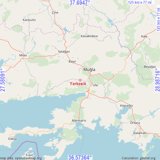
Yerkesik GPS coordinates[2]
37° 8' 10.5" North, 28° 17' 2.508" East
| Map corner | latitude | longitude |
|---|---|---|
| Upper-left | 37.6947°, | 27.58091° |
| Center: | 37.13625°, | 28.28403° |
| Lower-right: | 36.57364°, | 28.98716° |
| Map W x H: | 124.7×124.6 km | = 77.5×77.4mi |
| max Lat: | 42.02683° ⇑85.6% North |
| Yerkesik: | 37.13625° |
| min Lat: | ⇓14.4% South 35.9025° |
| min Long | Yerkesik | max Long |
| 25.90902° | 28.28403° | 44.60099° |
| W 11.8%⇐ | ⇒88.2% E |
Elevation
Elevation of Yerkesik is 664 m = 2178 ft, and this is 53.4 m = 175 ft below average elevation for this country.
| Max E: |
2682 m = 8799 ft | 51.7% |
| Avg. | 717.4 m = 2354 ft | |
| Yerkesik | 664 m = 2178 ft | |
Min E: |
0 m = 0 ft | 48.3% |
See also: Turkey elevation on elevation.city.
Geographical zone
Yerkesik is located in North temperate zone (between Tropic of Cancer and the Arctic Circle). Distance of this Northern Tropic circle is 1523.2 km =946.5 mi to South.| Distance of | km | miles | from Yerkesik |
|---|---|---|---|
| North Pole | 5877.9 | 3652.4 | to North |
| Arctic Circle | 3272 | 2033.1 | to North |
| Tropic Cancer | 1523.2 | 946.5 | to South |
| Equator | 4129.2 | 2565.8 | to South |


Nearby cities:
15 places around Yerkesik: (largest is in red/bold)
• Akçaova
46.7 km =29 mi,  330°
330°
• Bayır
15.8 km =9.8 mi,  337°
337°
• Bozarmut
21.7 km =13.5 mi, 332°
• Dalyan
46.4 km =28.8 mi,  136°
136°
• Göktepe
39.8 km =24.7 mi,  37°
37°
• Kavaklıdere
35 km =21.7 mi,  11°
11°
• Marmaris
31.3 km =19.4 mi,  181°
181°
• Menteşe
2.7 km =1.7 mi,  215°
215°
• Milas
48.6 km =30.2 mi,  294°
294°
• Muğla
11.7 km =7.3 mi, 38°
• Turgut
34.7 km =21.6 mi,  319°
319°
• Ula
12.3 km =7.6 mi,  106°
106°
• Yatağan
25.9 km =16.1 mi, 331°
• Yeşilyurt
6.4 km =4 mi,  353°
353°
• Ören
30.2 km =18.8 mi,  248°
248°
Sources, notices
• [Note1] Compared only with cities in Turkey existing in our database
• [Src1] Map data: © OpenStreetMap contributors (CC-BY-SA)
• [Src2] Other city data from geonames.org with taken over terms of usage.
• [Src3] Geographical zone / Annual Mean Temperature by Robert A. Rohde @ Wikipedia
