Niğde geodata
Niğde is a seat of a first-order administrative division; located in Turkey in Europe/Istanbul (GMT+3) time zone. With population of 91,039 people, there are 95 cities with bigger population in this country. Compared to other cities in Turkey, 62.2% of cities are located further ↑North; 55.8% of cities are located further →East and 82.3% of cities have lower elevation than Niğde. Note1


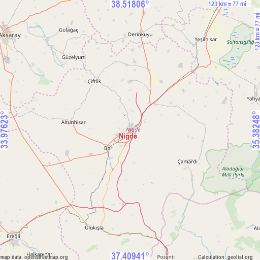
Niğde GPS coordinates[2]
37° 57' 56.988" North, 34° 40' 45.66" East
| Map corner | latitude | longitude |
|---|---|---|
| Upper-left | 38.51806°, | 33.97623° |
| Center: | 37.96583°, | 34.67935° |
| Lower-right: | 37.40941°, | 35.38248° |
| Map W x H: | 123.3×123.3 km | = 76.6×76.6mi |
| max Lat: | 42.02683° ⇑62.2% North |
| Niğde: | 37.96583° |
| min Lat: | ⇓37.8% South 35.9025° |
| min Long | Niğde | max Long |
| 25.90902° | 34.67935° | 44.60099° |
| W 44.2%⇐ | ⇒55.8% E |
Elevation
Elevation of Niğde is 1243 m = 4078 ft, and this is 525.6 m = 1724 ft above average elevation for this country.
| Max E: |
2682 m = 8799 ft | 17.7% |
| Niğde | 1243 m 4078 ft | |
| Avg. | 717.4 m = 2354 ft | |
Min E: |
0 m = 0 ft | 82.3% |
See also: Niğde elevation on elevation.city.
Geographical zone
Niğde is located in North temperate zone (between Tropic of Cancer and the Arctic Circle). Distance of this Northern Tropic circle is 1615.5 km =1003.8 mi to South.| Distance of | km | miles | from Niğde |
|---|---|---|---|
| North Pole | 5785.7 | 3595.1 | to North |
| Arctic Circle | 3179.8 | 1975.8 | to North |
| Tropic Cancer | 1615.5 | 1003.8 | to South |
| Equator | 4221.4 | 2623.1 | to South |


Nearby cities:
15 places around Niğde: (largest is in red/bold)
• Altunhisar
27 km =16.8 mi,  276°
276°
• Bor
13.5 km =8.4 mi,  231°
231°
• Derinkuyu
45.8 km =28.5 mi,  6°
6°
• Gülağaç
56 km =34.8 mi,  328°
328°
• Güzelyurt
43.8 km =27.2 mi,  322°
322°
• Kamışlı
51.4 km =31.9 mi,  152°
152°
• Kemerhisar
18.4 km =11.4 mi,  210°
210°
• Misli
30.7 km =19.1 mi,  16°
16°
• Taşpınar
62 km =38.5 mi,  292°
292°
• Ulukışla
49.5 km =30.8 mi,  200°
200°
• Yahyalı
61.3 km =38.1 mi,  75°
75°
• Yeşilhisar
55.9 km =34.7 mi,  39°
39°
• Çamardı
30.4 km =18.9 mi,  119°
119°
• Çiftehan
51 km =31.7 mi,  171°
171°
• Çiftlik
28.9 km =18 mi, 323°
Sources, notices
• [Note1] Compared only with cities in Turkey existing in our database
• [Src1] Map data: © OpenStreetMap contributors (CC-BY-SA)
• [Src2] Other city data from geonames.org with taken over terms of usage.
• [Src3] Geographical zone / Annual Mean Temperature by Robert A. Rohde @ Wikipedia
