Çamardı geodata
Çamardı (Niğde) is a seat of a second-order administrative division; located in Turkey in Europe/Istanbul (GMT+3) time zone. In our database, there are 1323 cities with bigger population. Compared to other cities in Turkey, 67.6% of cities are located further ↑North; 54.4% of cities are located further →East and 90.1% of cities have lower elevation than Çamardı. Note1


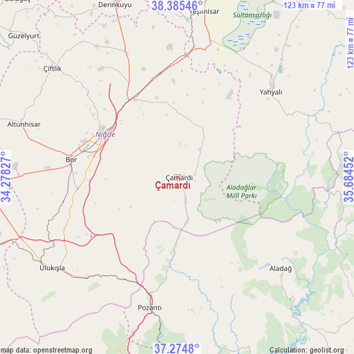
Çamardı GPS coordinates[2]
37° 49' 55.992" North, 34° 58' 53.004" East
| Map corner | latitude | longitude |
|---|---|---|
| Upper-left | 38.38546°, | 34.27827° |
| Center: | 37.83222°, | 34.98139° |
| Lower-right: | 37.2748°, | 35.68452° |
| Map W x H: | 123.5×123.5 km | = 76.7×76.7mi |
| max Lat: | 42.02683° ⇑67.6% North |
| Çamardı: | 37.83222° |
| min Lat: | ⇓32.4% South 35.9025° |
| min Long | Çamardı | max Long |
| 25.90902° | 34.98139° | 44.60099° |
| W 45.6%⇐ | ⇒54.4% E |
Elevation
Elevation of Çamardı is 1482 m = 4862 ft, and this is 764.6 m = 2509 ft above average elevation for this country.
| Max E: |
2682 m = 8799 ft | 9.9% |
| Çamardı | 1482 m 4862 ft | |
| Avg. | 717.4 m = 2354 ft | |
Min E: |
0 m = 0 ft | 90.1% |
See also: Turkey elevation on elevation.city.
Geographical zone
Çamardı is located in North temperate zone (between Tropic of Cancer and the Arctic Circle). Distance of this Northern Tropic circle is 1600.6 km =994.6 mi to South.| Distance of | km | miles | from Çamardı |
|---|---|---|---|
| North Pole | 5800.5 | 3604.3 | to North |
| Arctic Circle | 3194.6 | 1985 | to North |
| Tropic Cancer | 1600.6 | 994.6 | to South |
| Equator | 4206.5 | 2613.8 | to South |


Nearby cities:
15 places around Çamardı: (largest is in red/bold)
• Aladağ
48.2 km =30 mi,  130°
130°
• Altunhisar
56.2 km =34.9 mi,  288°
288°
• Bor
37.7 km =23.4 mi,  279°
279°
• Derinkuyu
64.1 km =39.8 mi,  340°
340°
• Kamışlı
30.9 km =19.2 mi,  185°
185°
• Kemerhisar
36 km =22.4 mi,  268°
268°
• Mansurlu
59.1 km =36.7 mi,  88°
88°
• Misli
47.8 km =29.7 mi, 337°
• Niğde
30.4 km =18.9 mi,  299°
299°
• Pozantı
46 km =28.6 mi, 192°
• Ulukışla
53.9 km =33.5 mi,  234°
234°
• Yahyalı
44.6 km =27.7 mi,  47°
47°
• Yeşilhisar
58.6 km =36.4 mi,  9°
9°
• Çiftehan
40.2 km =25 mi,  207°
207°
• Çiftlik
57.9 km =36 mi,  311°
311°
Sources, notices
• [Note1] Compared only with cities in Turkey existing in our database
• [Src1] Map data: © OpenStreetMap contributors (CC-BY-SA)
• [Src2] Other city data from geonames.org with taken over terms of usage.
• [Src3] Geographical zone / Annual Mean Temperature by Robert A. Rohde @ Wikipedia
