Bor geodata
Bor (Niğde) is a seat of a second-order administrative division; located in Turkey in Europe/Istanbul (GMT+3) time zone. With population of 32,435 people, there are 233 cities with bigger population in this country. Compared to other cities in Turkey, 65.3% of cities are located further ↑North; 56.2% of cities are located further →East and 75.6% of cities have lower elevation than Bor. Note1


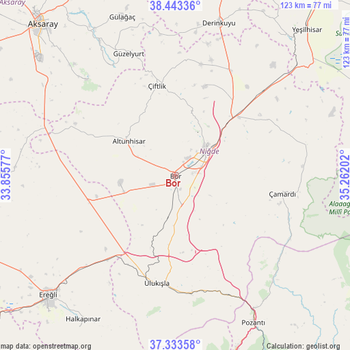
Bor GPS coordinates[2]
37° 53' 26.016" North, 34° 33' 32.004" East
| Map corner | latitude | longitude |
|---|---|---|
| Upper-left | 38.44336°, | 33.85577° |
| Center: | 37.89056°, | 34.55889° |
| Lower-right: | 37.33358°, | 35.26202° |
| Map W x H: | 123.4×123.4 km | = 76.7×76.7mi |
| max Lat: | 42.02683° ⇑65.3% North |
| Bor: | 37.89056° |
| min Lat: | ⇓34.7% South 35.9025° |
| min Long | Bor | max Long |
| 25.90902° | 34.55889° | 44.60099° |
| W 43.8%⇐ | ⇒56.2% E |
Elevation
Elevation of Bor is 1116 m = 3661 ft, and this is 398.6 m = 1308 ft above average elevation for this country.
| Max E: |
2682 m = 8799 ft | 24.4% |
| Bor | 1116 m 3661 ft | |
| Avg. | 717.4 m = 2354 ft | |
Min E: |
0 m = 0 ft | 75.6% |
See also: Turkey elevation on elevation.city.
Geographical zone
Bor is located in North temperate zone (between Tropic of Cancer and the Arctic Circle). Distance of this Northern Tropic circle is 1607.1 km =998.6 mi to South.| Distance of | km | miles | from Bor |
|---|---|---|---|
| North Pole | 5794 | 3600.2 | to North |
| Arctic Circle | 3188.1 | 1981 | to North |
| Tropic Cancer | 1607.1 | 998.6 | to South |
| Equator | 4213 | 2617.8 | to South |


Nearby cities:
15 places around Bor: (largest is in red/bold)
• Altunhisar
19.8 km =12.3 mi,  304°
304°
• Derinkuyu
56 km =34.8 mi,  15°
15°
• Gülağaç
59.2 km =36.8 mi,  341°
341°
• Güzelyurt
46 km =28.6 mi, 339°
• Halkapınar
60.4 km =37.5 mi,  212°
212°
• Kamışlı
50.6 km =31.4 mi,  137°
137°
• Kemerhisar
7.5 km =4.7 mi,  171°
171°
• Misli
42.4 km =26.3 mi,  26°
26°
• Niğde
13.5 km =8.4 mi,  51°
51°
• Pozantı
58.4 km =36.3 mi,  151°
151°
• Taşpınar
56.7 km =35.2 mi, 304°
• Ulukışla
38.7 km =24 mi,  189°
189°
• Çamardı
37.7 km =23.4 mi,  99°
99°
• Çiftehan
46 km =28.6 mi,  156°
156°
• Çiftlik
32.4 km =20.1 mi,  348°
348°
Sources, notices
• [Note1] Compared only with cities in Turkey existing in our database
• [Src1] Map data: © OpenStreetMap contributors (CC-BY-SA)
• [Src2] Other city data from geonames.org with taken over terms of usage.
• [Src3] Geographical zone / Annual Mean Temperature by Robert A. Rohde @ Wikipedia
