Obruk geodata
Obruk (Konya) is a seat of a third-order administrative division; located in Turkey in Europe/Istanbul (GMT+3) time zone. In our database, there are 1323 cities with bigger population. Compared to other cities in Turkey, 58.2% of cities are located further ↑North; 61.7% of cities are located further →East and 68% of cities have lower elevation than Obruk. Note1


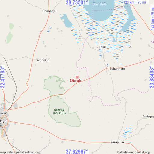
Obruk GPS coordinates[2]
38° 11' 3.984" North, 33° 10' 51.42" East
| Map corner | latitude | longitude |
|---|---|---|
| Upper-left | 38.73501°, | 32.47783° |
| Center: | 38.18444°, | 33.18095° |
| Lower-right: | 37.62967°, | 33.88408° |
| Map W x H: | 122.9×122.9 km | = 76.4×76.4mi |
| max Lat: | 42.02683° ⇑58.2% North |
| Obruk: | 38.18444° |
| min Lat: | ⇓41.8% South 35.9025° |
| min Long | Obruk | max Long |
| 25.90902° | 33.18095° | 44.60099° |
| W 38.3%⇐ | ⇒61.7% E |
Elevation
Elevation of Obruk is 999 m = 3278 ft, and this is 281.6 m = 924 ft above average elevation for this country.
| Max E: |
2682 m = 8799 ft | 32% |
| Obruk | 999 m 3278 ft | |
| Avg. | 717.4 m = 2354 ft | |
Min E: |
0 m = 0 ft | 68% |
See also: Turkey elevation on elevation.city.
Geographical zone
Obruk is located in North temperate zone (between Tropic of Cancer and the Arctic Circle). Distance of this Northern Tropic circle is 1639.8 km =1018.9 mi to South.| Distance of | km | miles | from Obruk |
|---|---|---|---|
| North Pole | 5761.4 | 3580 | to North |
| Arctic Circle | 3155.5 | 1960.7 | to North |
| Tropic Cancer | 1639.8 | 1018.9 | to South |
| Equator | 4245.7 | 2638.2 | to South |


Nearby cities:
15 places around Obruk: (largest is in red/bold)
• Altınekin
30.5 km =19 mi,  296°
296°
• Aşağıpınarbaşı
53.3 km =33.1 mi,  252°
252°
• Cihanbeyli
57.5 km =35.7 mi,  337°
337°
• Emirgazi
65.5 km =40.7 mi,  118°
118°
• Eskil
31.5 km =19.6 mi,  39°
39°
• Hotamış
61.7 km =38.3 mi,  168°
168°
• Karapınar
61.4 km =38.2 mi,  148°
148°
• Karatay
67.1 km =41.7 mi,  238°
238°
• Ovakavağı
56.9 km =35.4 mi,  202°
202°
• Sarayönü
68.4 km =42.5 mi,  277°
277°
• Selçuklu
68.9 km =42.8 mi, 241°
• Sultanhanı
33 km =20.5 mi,  77°
77°
• Yarma
49 km =30.4 mi,  212°
212°
• Yeşilova
62.6 km =38.9 mi,  66°
66°
• Çatalhöyük
65.2 km =40.5 mi, 208°
Sources, notices
• [Note1] Compared only with cities in Turkey existing in our database
• [Src1] Map data: © OpenStreetMap contributors (CC-BY-SA)
• [Src2] Other city data from geonames.org with taken over terms of usage.
• [Src3] Geographical zone / Annual Mean Temperature by Robert A. Rohde @ Wikipedia
