Karapınar geodata
Karapınar (Konya) is a seat of a second-order administrative division; located in Turkey in Europe/Istanbul (GMT+3) time zone. With population of 49,509 people, there are 177 cities with bigger population in this country. Compared to other cities in Turkey, 70.2% of cities are located further ↑North; 60.1% of cities are located further →East and 67.8% of cities have lower elevation than Karapınar. Note1


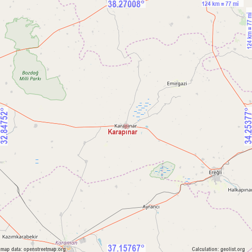
Karapınar GPS coordinates[2]
37° 42' 57.456" North, 33° 33' 2.304" East
| Map corner | latitude | longitude |
|---|---|---|
| Upper-left | 38.27008°, | 32.84752° |
| Center: | 37.71596°, | 33.55064° |
| Lower-right: | 37.15767°, | 34.25377° |
| Map W x H: | 123.7×123.7 km | = 76.9×76.9mi |
| max Lat: | 42.02683° ⇑70.2% North |
| Karapınar: | 37.71596° |
| min Lat: | ⇓29.8% South 35.9025° |
| min Long | Karapınar | max Long |
| 25.90902° | 33.55064° | 44.60099° |
| W 39.9%⇐ | ⇒60.1% E |
Elevation
Elevation of Karapınar is 995 m = 3264 ft, and this is 277.6 m = 911 ft above average elevation for this country.
| Max E: |
2682 m = 8799 ft | 32.2% |
| Karapınar | 995 m 3264 ft | |
| Avg. | 717.4 m = 2354 ft | |
Min E: |
0 m = 0 ft | 67.8% |
See also: Karapınar elevation on elevation.city.
Geographical zone
Karapınar is located in North temperate zone (between Tropic of Cancer and the Arctic Circle). Distance of this Northern Tropic circle is 1587.7 km =986.6 mi to South.| Distance of | km | miles | from Karapınar |
|---|---|---|---|
| North Pole | 5813.4 | 3612.3 | to North |
| Arctic Circle | 3207.6 | 1993.1 | to North |
| Tropic Cancer | 1587.7 | 986.6 | to South |
| Equator | 4193.6 | 2605.8 | to South |


Nearby cities:
15 places around Karapınar: (largest is in red/bold)
• Ayrancı
41.3 km =25.7 mi,  162°
162°
• Beyviran
31 km =19.3 mi,  61°
61°
• Emirgazi
32.6 km =20.3 mi,  50°
50°
• Ereğli
49.2 km =30.6 mi,  117°
117°
• Halkapınar
64.3 km =40 mi, 119°
• Hotamış
22.1 km =13.7 mi,  247°
247°
• Kılbasan
54.1 km =33.6 mi,  216°
216°
• Obruk
61.4 km =38.2 mi,  328°
328°
• Ovakavağı
54.2 km =33.7 mi,  269°
269°
• Sultanhanı
59.1 km =36.7 mi,  359°
359°
• Yarma
59.7 km =37.1 mi,  280°
280°
• Yeşildere
62.3 km =38.7 mi,  182°
182°
• Çatalhöyük
63.9 km =39.7 mi, 265°
• Çiğil
33.4 km =20.8 mi, 217°
• İnönü
48.3 km =30 mi, 156°
Sources, notices
• [Note1] Compared only with cities in Turkey existing in our database
• [Src1] Map data: © OpenStreetMap contributors (CC-BY-SA)
• [Src2] Other city data from geonames.org with taken over terms of usage.
• [Src3] Geographical zone / Annual Mean Temperature by Robert A. Rohde @ Wikipedia
