Sarıveliler geodata
Sarıveliler (Karaman) is a seat of a second-order administrative division; located in Turkey in Europe/Istanbul (GMT+3) time zone. With population of 7,507 people, there are 596 cities with bigger population in this country. Compared to other cities in Turkey, 95.4% of cities are located further ↑North; 64% of cities are located further →East and 90.4% of cities have lower elevation than Sarıveliler. Note1


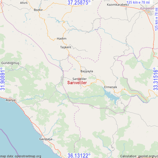
Sarıveliler GPS coordinates[2]
36° 41' 49.38" North, 32° 36' 43.308" East
| Map corner | latitude | longitude |
|---|---|---|
| Upper-left | 37.25875°, | 31.90891° |
| Center: | 36.69705°, | 32.61203° |
| Lower-right: | 36.13122°, | 33.31516° |
| Map W x H: | 125.4×125.4 km | = 77.9×77.9mi |
| max Lat: | 42.02683° ⇑95.4% North |
| Sarıveliler: | 36.69705° |
| min Lat: | ⇓4.6% South 35.9025° |
| min Long | Sarıveliler | max Long |
| 25.90902° | 32.61203° | 44.60099° |
| W 36%⇐ | ⇒64% E |
Elevation
Elevation of Sarıveliler is 1490 m = 4888 ft, and this is 772.6 m = 2535 ft above average elevation for this country.
| Max E: |
2682 m = 8799 ft | 9.6% |
| Sarıveliler | 1490 m 4888 ft | |
| Avg. | 717.4 m = 2354 ft | |
Min E: |
0 m = 0 ft | 90.4% |
See also: Turkey elevation on elevation.city.
Geographical zone
Sarıveliler is located in North temperate zone (between Tropic of Cancer and the Arctic Circle). Distance of this Northern Tropic circle is 1474.4 km =916.1 mi to South.| Distance of | km | miles | from Sarıveliler |
|---|---|---|---|
| North Pole | 5926.7 | 3682.7 | to North |
| Arctic Circle | 3320.8 | 2063.4 | to North |
| Tropic Cancer | 1474.4 | 916.1 | to South |
| Equator | 4080.3 | 2535.4 | to South |


Nearby cities:
15 places around Sarıveliler: (largest is in red/bold)
• Alanya
57.2 km =35.5 mi,  252°
252°
• Başyayla
8.7 km =5.4 mi,  44°
44°
• Bucakkışla
46.4 km =28.8 mi,  51°
51°
• Demirtaş
48.1 km =29.9 mi,  231°
231°
• Eksere
56.1 km =34.9 mi,  283°
283°
• Ermenek
25.7 km =16 mi,  104°
104°
• Gazipaşa
54.3 km =33.7 mi,  208°
208°
• Göktepe
7.9 km =4.9 mi,  172°
172°
• Hadim
35.2 km =21.9 mi,  336°
336°
• Kazancı
31.1 km =19.3 mi,  134°
134°
• Köprülü
38.3 km =23.8 mi, 275°
• Mahmutlar
51.7 km =32.1 mi,  244°
244°
• Taşkent
27.5 km =17.1 mi, 336°
• Tepebaşı
10.4 km =6.5 mi,  109°
109°
• Üçpınar
57.7 km =35.9 mi,  327°
327°
Sources, notices
• [Note1] Compared only with cities in Turkey existing in our database
• [Src1] Map data: © OpenStreetMap contributors (CC-BY-SA)
• [Src2] Other city data from geonames.org with taken over terms of usage.
• [Src3] Geographical zone / Annual Mean Temperature by Robert A. Rohde @ Wikipedia
