Göktepe geodata
Göktepe (Karaman) is a seat of a third-order administrative division; located in Turkey in Europe/Istanbul (GMT+3) time zone. In our database, there are 1323 cities with bigger population. Compared to other cities in Turkey, 96.1% of cities are located further ↑North; 63.9% of cities are located further →East and 83.7% of cities have lower elevation than Göktepe. Note1


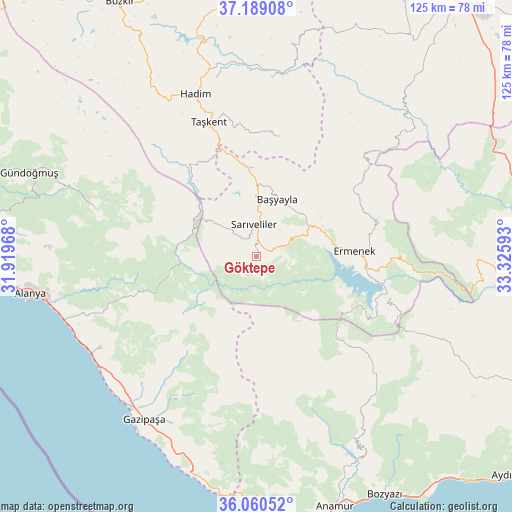
Göktepe GPS coordinates[2]
36° 37' 36.732" North, 32° 37' 22.08" East
| Map corner | latitude | longitude |
|---|---|---|
| Upper-left | 37.18908°, | 31.91968° |
| Center: | 36.62687°, | 32.6228° |
| Lower-right: | 36.06052°, | 33.32593° |
| Map W x H: | 125.5×125.5 km | = 78×78mi |
| max Lat: | 42.02683° ⇑96.1% North |
| Göktepe: | 36.62687° |
| min Lat: | ⇓3.9% South 35.9025° |
| min Long | Göktepe | max Long |
| 25.90902° | 32.6228° | 44.60099° |
| W 36.1%⇐ | ⇒63.9% E |
Elevation
Elevation of Göktepe is 1278 m = 4193 ft, and this is 560.6 m = 1839 ft above average elevation for this country.
| Max E: |
2682 m = 8799 ft | 16.3% |
| Göktepe | 1278 m 4193 ft | |
| Avg. | 717.4 m = 2354 ft | |
Min E: |
0 m = 0 ft | 83.7% |
See also: Turkey elevation on elevation.city.
Geographical zone
Göktepe is located in North temperate zone (between Tropic of Cancer and the Arctic Circle). Distance of this Northern Tropic circle is 1466.6 km =911.3 mi to South.| Distance of | km | miles | from Göktepe |
|---|---|---|---|
| North Pole | 5934.5 | 3687.5 | to North |
| Arctic Circle | 3328.6 | 2068.3 | to North |
| Tropic Cancer | 1466.6 | 911.3 | to South |
| Equator | 4072.5 | 2530.5 | to South |


Nearby cities:
15 places around Göktepe: (largest is in red/bold)
• Alanya
56.4 km =35 mi,  260°
260°
• Anamur
64.3 km =40 mi,  162°
162°
• Başyayla
15 km =9.3 mi,  19°
19°
• Bucakkışla
50.9 km =31.6 mi,  44°
44°
• Demirtaş
44.5 km =27.7 mi,  239°
239°
• Eksere
59.3 km =36.8 mi,  290°
290°
• Ermenek
24 km =14.9 mi,  86°
86°
• Gazipaşa
48.2 km =30 mi,  214°
214°
• Hadim
42.8 km =26.6 mi,  339°
339°
• Kazancı
25.4 km =15.8 mi,  123°
123°
• Köprülü
40.8 km =25.4 mi, 286°
• Mahmutlar
49.7 km =30.9 mi,  252°
252°
• Sarıveliler
7.9 km =4.9 mi,  352°
352°
• Taşkent
35.1 km =21.8 mi, 340°
• Tepebaşı
9.9 km =6.2 mi,  63°
63°
Sources, notices
• [Note1] Compared only with cities in Turkey existing in our database
• [Src1] Map data: © OpenStreetMap contributors (CC-BY-SA)
• [Src2] Other city data from geonames.org with taken over terms of usage.
• [Src3] Geographical zone / Annual Mean Temperature by Robert A. Rohde @ Wikipedia
