Samsat geodata
Samsat (Adıyaman) is a seat of a second-order administrative division; located in Turkey in Europe/Istanbul (GMT+3) time zone. With population of 9,308 people, there are 524 cities with bigger population in this country. Compared to other cities in Turkey, 72.6% of cities are located further ↑North; 64% of cities are located further ←West and 55% of cities have higher elevation than Samsat. Note1


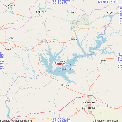
Samsat GPS coordinates[2]
37° 34' 54.984" North, 38° 28' 27.012" East
| Map corner | latitude | longitude |
|---|---|---|
| Upper-left | 38.13707°, | 37.77105° |
| Center: | 37.58194°, | 38.47417° |
| Lower-right: | 37.02264°, | 39.1773° |
| Map W x H: | 123.9×123.9 km | = 77×77mi |
| max Lat: | 42.02683° ⇑72.6% North |
| Samsat: | 37.58194° |
| min Lat: | ⇓27.4% South 35.9025° |
| min Long | Samsat | max Long |
| 25.90902° | 38.47417° | 44.60099° |
| W 64%⇐ | ⇒36% E |
Elevation
Elevation of Samsat is 587 m = 1926 ft, and this is 130.4 m = 428 ft below average elevation for this country.
| Max E: |
2682 m = 8799 ft | 55% |
| Avg. | 717.4 m = 2354 ft | |
| Samsat | 587 m = 1926 ft | |
Min E: |
0 m = 0 ft | 45% |
See also: Turkey elevation on elevation.city.
Geographical zone
Samsat is located in North temperate zone (between Tropic of Cancer and the Arctic Circle). Distance of this Northern Tropic circle is 1572.8 km =977.3 mi to South.| Distance of | km | miles | from Samsat |
|---|---|---|---|
| North Pole | 5828.3 | 3621.5 | to North |
| Arctic Circle | 3222.5 | 2002.4 | to North |
| Tropic Cancer | 1572.8 | 977.3 | to South |
| Equator | 4178.7 | 2596.5 | to South |


Nearby cities:
15 places around Samsat: (largest is in red/bold)
• Adıyaman
26.7 km =16.6 mi,  319°
319°
• Akpınar
22.3 km =13.9 mi,  267°
267°
• Akziyaret
38.1 km =23.7 mi,  131°
131°
• Akıncılar
36.8 km =22.9 mi,  56°
56°
• Bağpınar
13.7 km =8.5 mi, 274°
• Bozova
24.8 km =15.4 mi,  169°
169°
• Damlacık
40.2 km =25 mi,  23°
23°
• Hilvan
42.4 km =26.3 mi,  89°
89°
• Kuyucak
33.3 km =20.7 mi,  339°
339°
• Kâhta
26.2 km =16.3 mi,  30°
30°
• Kızılin
35.3 km =21.9 mi,  263°
263°
• Narince
41.8 km =26 mi,  36°
36°
• Ovacık
28 km =17.4 mi,  105°
105°
• Yaylak
25.2 km =15.7 mi,  208°
208°
• Şambayat
39.3 km =24.4 mi,  286°
286°
Sources, notices
• [Note1] Compared only with cities in Turkey existing in our database
• [Src1] Map data: © OpenStreetMap contributors (CC-BY-SA)
• [Src2] Other city data from geonames.org with taken over terms of usage.
• [Src3] Geographical zone / Annual Mean Temperature by Robert A. Rohde @ Wikipedia
