Bucakkışla geodata
Bucakkışla (Karaman) is a seat of a third-order administrative division; located in Turkey in Europe/Istanbul (GMT+3) time zone. In our database, there are 1323 cities with bigger population. Compared to other cities in Turkey, 89.1% of cities are located further ↑North; 62.1% of cities are located further →East and 63.9% of cities have higher elevation than Bucakkışla. Note1


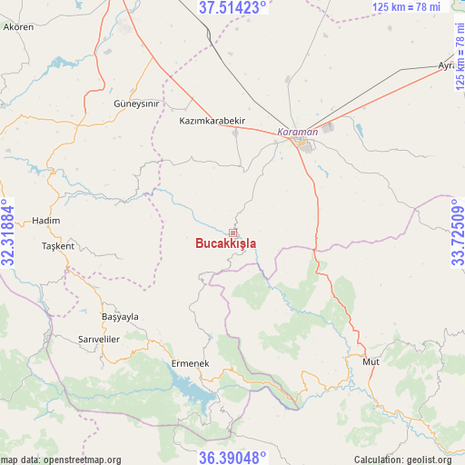
Bucakkışla GPS coordinates[2]
36° 57' 15.948" North, 33° 1' 19.056" East
| Map corner | latitude | longitude |
|---|---|---|
| Upper-left | 37.51423°, | 32.31884° |
| Center: | 36.95443°, | 33.02196° |
| Lower-right: | 36.39048°, | 33.72509° |
| Map W x H: | 124.9×124.9 km | = 77.6×77.6mi |
| max Lat: | 42.02683° ⇑89.1% North |
| Bucakkışla: | 36.95443° |
| min Lat: | ⇓10.9% South 35.9025° |
| min Long | Bucakkışla | max Long |
| 25.90902° | 33.02196° | 44.60099° |
| W 37.9%⇐ | ⇒62.1% E |
Elevation
Elevation of Bucakkışla is 435 m = 1427 ft, and this is 282.4 m = 927 ft below average elevation for this country.
| Max E: |
2682 m = 8799 ft | 63.9% |
| Avg. | 717.4 m = 2354 ft | |
| Bucakkışla | 435 m = 1427 ft | |
Min E: |
0 m = 0 ft | 36.1% |
See also: Turkey elevation on elevation.city.
Geographical zone
Bucakkışla is located in North temperate zone (between Tropic of Cancer and the Arctic Circle). Distance of this Northern Tropic circle is 1503 km =933.9 mi to South.| Distance of | km | miles | from Bucakkışla |
|---|---|---|---|
| North Pole | 5898.1 | 3664.9 | to North |
| Arctic Circle | 3292.2 | 2045.7 | to North |
| Tropic Cancer | 1503 | 933.9 | to South |
| Equator | 4108.9 | 2553.2 | to South |


Nearby cities:
15 places around Bucakkışla: (largest is in red/bold)
• Başyayla
37.7 km =23.4 mi,  233°
233°
• Belören
50.6 km =31.4 mi,  304°
304°
• Ermenek
36.8 km =22.9 mi,  198°
198°
• Göktepe
50.9 km =31.6 mi,  224°
224°
• Güneysınır
43.6 km =27.1 mi,  323°
323°
• Hadim
50.3 km =31.3 mi,  274°
274°
• Karaman
30.5 km =19 mi,  34°
34°
• Kazancı
52.3 km =32.5 mi, 195°
• Kazımkarabekir
31.2 km =19.4 mi,  349°
349°
• Kılbasan
43.7 km =27.2 mi,  19°
19°
• Mut
50.7 km =31.5 mi,  132°
132°
• Sarıveliler
46.4 km =28.8 mi, 231°
• Taşkent
47.3 km =29.4 mi, 265°
• Tepebaşı
41.7 km =25.9 mi, 219°
• Yeşildere
49.1 km =30.5 mi,  62°
62°
Sources, notices
• [Note1] Compared only with cities in Turkey existing in our database
• [Src1] Map data: © OpenStreetMap contributors (CC-BY-SA)
• [Src2] Other city data from geonames.org with taken over terms of usage.
• [Src3] Geographical zone / Annual Mean Temperature by Robert A. Rohde @ Wikipedia
