Ereğli geodata
Ereğli (Konya) is a populated place; located in Turkey in Europe/Istanbul (GMT+3) time zone. With population of 92,117 people, there are 92 cities with bigger population in this country. Compared to other cities in Turkey, 74.4% of cities are located further ↑North; 58.1% of cities are located further →East and 71.8% of cities have lower elevation than Ereğli. Note1


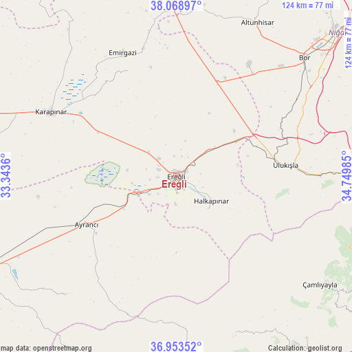
Ereğli GPS coordinates[2]
37° 30' 47.988" North, 34° 2' 48.192" East
| Map corner | latitude | longitude |
|---|---|---|
| Upper-left | 38.06897°, | 33.3436° |
| Center: | 37.51333°, | 34.04672° |
| Lower-right: | 36.95352°, | 34.74985° |
| Map W x H: | 124×124 km | = 77.1×77.1mi |
| max Lat: | 42.02683° ⇑74.4% North |
| Ereğli: | 37.51333° |
| min Lat: | ⇓25.6% South 35.9025° |
| min Long | Ereğli | max Long |
| 25.90902° | 34.04672° | 44.60099° |
| W 41.9%⇐ | ⇒58.1% E |
Elevation
Elevation of Ereğli is 1053 m = 3455 ft, and this is 335.6 m = 1101 ft above average elevation for this country.
| Max E: |
2682 m = 8799 ft | 28.2% |
| Ereğli | 1053 m 3455 ft | |
| Avg. | 717.4 m = 2354 ft | |
Min E: |
0 m = 0 ft | 71.8% |
See also: Ereğli elevation on elevation.city.
Geographical zone
Ereğli is located in North temperate zone (between Tropic of Cancer and the Arctic Circle). Distance of this Northern Tropic circle is 1565.2 km =972.6 mi to South.| Distance of | km | miles | from Ereğli |
|---|---|---|---|
| North Pole | 5836 | 3626.3 | to North |
| Arctic Circle | 3230.1 | 2007.1 | to North |
| Tropic Cancer | 1565.2 | 972.6 | to South |
| Equator | 4171.1 | 2591.8 | to South |


Nearby cities:
15 places around Ereğli: (largest is in red/bold)
• Altunhisar
60.4 km =37.5 mi,  28°
28°
• Arslanköy
59 km =36.7 mi,  158°
158°
• Ayrancı
35.9 km =22.3 mi,  241°
241°
• Beyviran
40.8 km =25.4 mi,  336°
336°
• Bor
61.6 km =38.3 mi,  47°
47°
• Emirgazi
47 km =29.2 mi, 336°
• Halkapınar
15.2 km =9.4 mi,  125°
125°
• Karapınar
49.2 km =30.6 mi,  297°
297°
• Kemerhisar
57.7 km =35.9 mi, 53°
• Ulukışla
38.9 km =24.2 mi,  84°
84°
• Yeşildere
61.5 km =38.2 mi,  229°
229°
• Çamlıyayla
61.8 km =38.4 mi, 128°
• Çiftehan
63.7 km =39.6 mi,  90°
90°
• Çiğil
64.4 km =40 mi,  266°
266°
• İnönü
33 km =20.5 mi, 228°
Sources, notices
• [Note1] Compared only with cities in Turkey existing in our database
• [Src1] Map data: © OpenStreetMap contributors (CC-BY-SA)
• [Src2] Other city data from geonames.org with taken over terms of usage.
• [Src3] Geographical zone / Annual Mean Temperature by Robert A. Rohde @ Wikipedia
