İnönü geodata
İnönü (Karaman) is a populated place; located in Turkey in Europe/Istanbul (GMT+3) time zone. With population of 5,552 people, there are 681 cities with bigger population in this country. Compared to other cities in Turkey, 79.8% of cities are located further ↑North; 59.2% of cities are located further →East and 82.9% of cities have lower elevation than İnönü. Note1


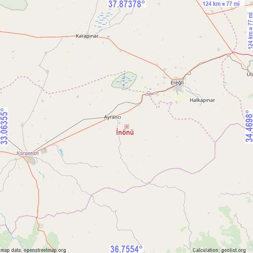
İnönü GPS coordinates[2]
37° 19' 0.012" North, 33° 46' 0.012" East
| Map corner | latitude | longitude |
|---|---|---|
| Upper-left | 37.87378°, | 33.06355° |
| Center: | 37.31667°, | 33.76667° |
| Lower-right: | 36.7554°, | 34.4698° |
| Map W x H: | 124.4×124.4 km | = 77.3×77.3mi |
| max Lat: | 42.02683° ⇑79.8% North |
| İnönü: | 37.31667° |
| min Lat: | ⇓20.2% South 35.9025° |
| min Long | İnönü | max Long |
| 25.90902° | 33.76667° | 44.60099° |
| W 40.8%⇐ | ⇒59.2% E |
Elevation
Elevation of İnönü is 1256 m = 4121 ft, and this is 538.6 m = 1767 ft above average elevation for this country.
| Max E: |
2682 m = 8799 ft | 17.1% |
| İnönü | 1256 m 4121 ft | |
| Avg. | 717.4 m = 2354 ft | |
Min E: |
0 m = 0 ft | 82.9% |
See also: Turkey elevation on elevation.city.
Geographical zone
İnönü is located in North temperate zone (between Tropic of Cancer and the Arctic Circle). Distance of this Northern Tropic circle is 1543.3 km =959 mi to South.| Distance of | km | miles | from İnönü |
|---|---|---|---|
| North Pole | 5857.8 | 3639.9 | to North |
| Arctic Circle | 3251.9 | 2020.6 | to North |
| Tropic Cancer | 1543.3 | 959 | to South |
| Equator | 4149.2 | 2578.2 | to South |


Nearby cities:
15 places around İnönü: (largest is in red/bold)
• Arslanköy
56.8 km =35.3 mi,  125°
125°
• Ayrancı
8.5 km =5.3 mi,  305°
305°
• Beyviran
59.8 km =37.2 mi,  7°
7°
• Emirgazi
65.4 km =40.6 mi, 5°
• Ereğli
33 km =20.5 mi,  48°
48°
• Güzeloluk
64.5 km =40.1 mi,  154°
154°
• Halkapınar
39.4 km =24.5 mi,  70°
70°
• Hotamış
53.4 km =33.2 mi, 312°
• Karaman
51.1 km =31.8 mi,  252°
252°
• Karapınar
48.3 km =30 mi,  336°
336°
• Kılbasan
51.3 km =31.9 mi,  271°
271°
• Kırobası
66.7 km =41.4 mi,  172°
172°
• Ulukışla
68.5 km =42.6 mi, 67°
• Yeşildere
28.5 km =17.7 mi,  231°
231°
• Çiğil
43.6 km =27.1 mi,  294°
294°
Sources, notices
• [Note1] Compared only with cities in Turkey existing in our database
• [Src1] Map data: © OpenStreetMap contributors (CC-BY-SA)
• [Src2] Other city data from geonames.org with taken over terms of usage.
• [Src3] Geographical zone / Annual Mean Temperature by Robert A. Rohde @ Wikipedia
