Beyviran geodata
Beyviran (Konya) is a seat of a third-order administrative division; located in Turkey in Europe/Istanbul (GMT+3) time zone. In our database, there are 1323 cities with bigger population. Compared to other cities in Turkey, 67% of cities are located further ↑North; 58.8% of cities are located further →East and 87.5% of cities have lower elevation than Beyviran. Note1


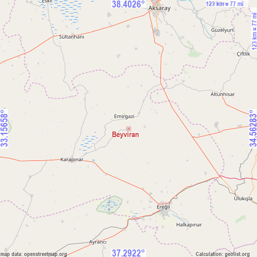
Beyviran GPS coordinates[2]
37° 50' 58.164" North, 33° 51' 34.92" East
| Map corner | latitude | longitude |
|---|---|---|
| Upper-left | 38.4026°, | 33.15658° |
| Center: | 37.84949°, | 33.8597° |
| Lower-right: | 37.2922°, | 34.56283° |
| Map W x H: | 123.5×123.5 km | = 76.7×76.7mi |
| max Lat: | 42.02683° ⇑67% North |
| Beyviran: | 37.84949° |
| min Lat: | ⇓33% South 35.9025° |
| min Long | Beyviran | max Long |
| 25.90902° | 33.8597° | 44.60099° |
| W 41.2%⇐ | ⇒58.8% E |
Elevation
Elevation of Beyviran is 1387 m = 4551 ft, and this is 669.6 m = 2197 ft above average elevation for this country.
| Max E: |
2682 m = 8799 ft | 12.5% |
| Beyviran | 1387 m 4551 ft | |
| Avg. | 717.4 m = 2354 ft | |
Min E: |
0 m = 0 ft | 87.5% |
See also: Turkey elevation on elevation.city.
Geographical zone
Beyviran is located in North temperate zone (between Tropic of Cancer and the Arctic Circle). Distance of this Northern Tropic circle is 1602.5 km =995.7 mi to South.| Distance of | km | miles | from Beyviran |
|---|---|---|---|
| North Pole | 5798.6 | 3603.1 | to North |
| Arctic Circle | 3192.7 | 1983.9 | to North |
| Tropic Cancer | 1602.5 | 995.7 | to South |
| Equator | 4208.5 | 2615 | to South |


Nearby cities:
15 places around Beyviran: (largest is in red/bold)
• Aksaray
59.9 km =37.2 mi,  13°
13°
• Altunhisar
47.7 km =29.6 mi,  70°
70°
• Ayrancı
56.3 km =35 mi,  195°
195°
• Bor
61.5 km =38.2 mi,  85°
85°
• Emirgazi
6.2 km =3.9 mi,  341°
341°
• Ereğli
40.8 km =25.4 mi,  156°
156°
• Halkapınar
54.5 km =33.9 mi,  148°
148°
• Hotamış
53 km =32.9 mi,  243°
243°
• Karapınar
31 km =19.3 mi, 241°
• Kemerhisar
62.6 km =38.9 mi, 92°
• Sultanhanı
51.9 km =32.2 mi,  328°
328°
• Taşpınar
39.5 km =24.5 mi,  21°
21°
• Yeşilova
62.3 km =38.7 mi,  358°
358°
• Çiğil
63 km =39.1 mi,  229°
229°
• İnönü
59.8 km =37.2 mi,  187°
187°
Sources, notices
• [Note1] Compared only with cities in Turkey existing in our database
• [Src1] Map data: © OpenStreetMap contributors (CC-BY-SA)
• [Src2] Other city data from geonames.org with taken over terms of usage.
• [Src3] Geographical zone / Annual Mean Temperature by Robert A. Rohde @ Wikipedia
