Altunhisar geodata
Altunhisar (Niğde) is a seat of a second-order administrative division; located in Turkey in Europe/Istanbul (GMT+3) time zone. With population of 3,658 people, there are 810 cities with bigger population in this country. Compared to other cities in Turkey, 61.6% of cities are located further ↑North; 57.1% of cities are located further →East and 81.2% of cities have lower elevation than Altunhisar. Note1


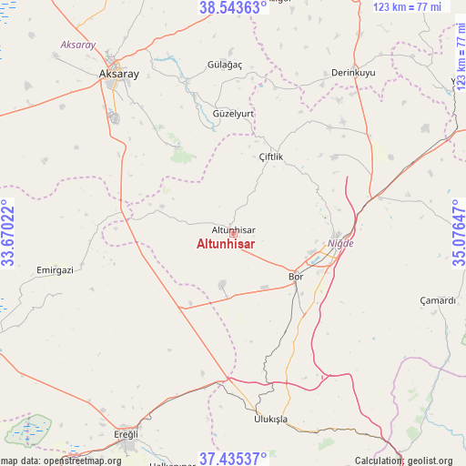
Altunhisar GPS coordinates[2]
37° 59' 29.724" North, 34° 22' 24.024" East
| Map corner | latitude | longitude |
|---|---|---|
| Upper-left | 38.54363°, | 33.67022° |
| Center: | 37.99159°, | 34.37334° |
| Lower-right: | 37.43537°, | 35.07647° |
| Map W x H: | 123.2×123.2 km | = 76.6×76.6mi |
| max Lat: | 42.02683° ⇑61.6% North |
| Altunhisar: | 37.99159° |
| min Lat: | ⇓38.4% South 35.9025° |
| min Long | Altunhisar | max Long |
| 25.90902° | 34.37334° | 44.60099° |
| W 42.9%⇐ | ⇒57.1% E |
Elevation
Elevation of Altunhisar is 1218 m = 3996 ft, and this is 500.6 m = 1642 ft above average elevation for this country.
| Max E: |
2682 m = 8799 ft | 18.8% |
| Altunhisar | 1218 m 3996 ft | |
| Avg. | 717.4 m = 2354 ft | |
Min E: |
0 m = 0 ft | 81.2% |
See also: Turkey elevation on elevation.city.
Geographical zone
Altunhisar is located in North temperate zone (between Tropic of Cancer and the Arctic Circle). Distance of this Northern Tropic circle is 1618.3 km =1005.6 mi to South.| Distance of | km | miles | from Altunhisar |
|---|---|---|---|
| North Pole | 5782.8 | 3593.3 | to North |
| Arctic Circle | 3176.9 | 1974 | to North |
| Tropic Cancer | 1618.3 | 1005.6 | to South |
| Equator | 4224.3 | 2624.9 | to South |


Nearby cities:
15 places around Altunhisar: (largest is in red/bold)
• Aksaray
52.1 km =32.4 mi,  324°
324°
• Beyviran
47.7 km =29.6 mi,  250°
250°
• Bor
19.8 km =12.3 mi,  124°
124°
• Derinkuyu
53 km =32.9 mi,  36°
36°
• Emirgazi
48 km =29.8 mi,  258°
258°
• Ereğli
60.4 km =37.5 mi,  208°
208°
• Gülağaç
45 km =28 mi,  356°
356°
• Güzelyurt
31.8 km =19.8 mi, 359°
• Kemerhisar
25.5 km =15.8 mi,  137°
137°
• Misli
44.2 km =27.5 mi,  52°
52°
• Niğde
27 km =16.8 mi,  96°
96°
• Taşpınar
37 km =23 mi,  304°
304°
• Ulukışla
50.3 km =31.3 mi,  168°
168°
• Çamardı
56.2 km =34.9 mi,  108°
108°
• Çiftlik
22.7 km =14.1 mi,  25°
25°
Sources, notices
• [Note1] Compared only with cities in Turkey existing in our database
• [Src1] Map data: © OpenStreetMap contributors (CC-BY-SA)
• [Src2] Other city data from geonames.org with taken over terms of usage.
• [Src3] Geographical zone / Annual Mean Temperature by Robert A. Rohde @ Wikipedia
