Güzelyurt geodata
Güzelyurt (Aksaray) is a seat of a second-order administrative division; located in Turkey in Europe/Istanbul (GMT+3) time zone. With population of 3,748 people, there are 802 cities with bigger population in this country. Compared to other cities in Turkey, 56.6% of cities are located further ↑North; 57.2% of cities are located further →East and 90.9% of cities have lower elevation than Güzelyurt. Note1


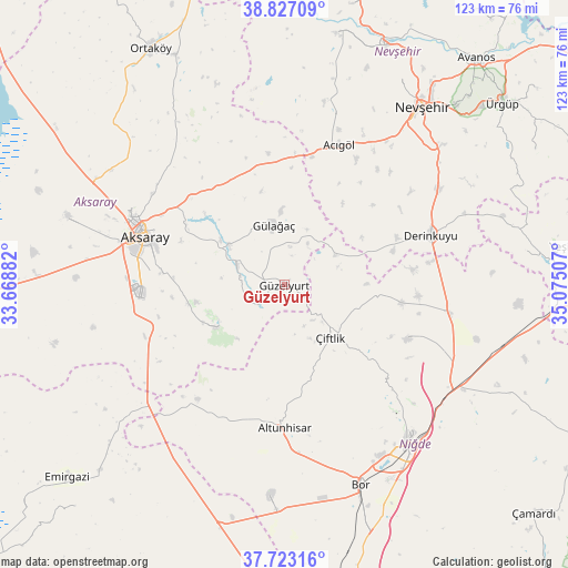
Güzelyurt GPS coordinates[2]
38° 16' 37.992" North, 34° 22' 18.984" East
| Map corner | latitude | longitude |
|---|---|---|
| Upper-left | 38.82709°, | 33.66882° |
| Center: | 38.27722°, | 34.37194° |
| Lower-right: | 37.72316°, | 35.07507° |
| Map W x H: | 122.7×122.7 km | = 76.2×76.2mi |
| max Lat: | 42.02683° ⇑56.6% North |
| Güzelyurt: | 38.27722° |
| min Lat: | ⇓43.4% South 35.9025° |
| min Long | Güzelyurt | max Long |
| 25.90902° | 34.37194° | 44.60099° |
| W 42.8%⇐ | ⇒57.2% E |
Elevation
Elevation of Güzelyurt is 1503 m = 4931 ft, and this is 785.6 m = 2577 ft above average elevation for this country.
| Max E: |
2682 m = 8799 ft | 9.1% |
| Güzelyurt | 1503 m 4931 ft | |
| Avg. | 717.4 m = 2354 ft | |
Min E: |
0 m = 0 ft | 90.9% |
See also: Turkey elevation on elevation.city.
Geographical zone
Güzelyurt is located in North temperate zone (between Tropic of Cancer and the Arctic Circle). Distance of this Northern Tropic circle is 1650.1 km =1025.3 mi to South.| Distance of | km | miles | from Güzelyurt |
|---|---|---|---|
| North Pole | 5751 | 3573.5 | to North |
| Arctic Circle | 3145.1 | 1954.3 | to North |
| Tropic Cancer | 1650.1 | 1025.3 | to South |
| Equator | 4256 | 2644.6 | to South |


Nearby cities:
15 places around Güzelyurt: (largest is in red/bold)
• Acıgöl
32.6 km =20.3 mi,  21°
21°
• Acıpınar
53.1 km =33 mi,  301°
301°
• Aksaray
32 km =19.9 mi,  289°
289°
• Altunhisar
31.8 km =19.8 mi,  179°
179°
• Balcı
55.1 km =34.2 mi,  334°
334°
• Bor
46 km =28.6 mi,  159°
159°
• Derinkuyu
33.4 km =20.8 mi,  70°
70°
• Gülağaç
13.4 km =8.3 mi,  350°
350°
• Kemerhisar
53.3 km =33.1 mi, 160°
• Misli
35.7 km =22.2 mi,  98°
98°
• Nevşehir
48.7 km =30.3 mi,  37°
37°
• Niğde
43.8 km =27.2 mi,  142°
142°
• Taşpınar
32.2 km =20 mi,  250°
250°
• Yeşilova
48.8 km =30.3 mi, 287°
• Çiftlik
15 km =9.3 mi, 138°
Sources, notices
• [Note1] Compared only with cities in Turkey existing in our database
• [Src1] Map data: © OpenStreetMap contributors (CC-BY-SA)
• [Src2] Other city data from geonames.org with taken over terms of usage.
• [Src3] Geographical zone / Annual Mean Temperature by Robert A. Rohde @ Wikipedia
