Çiftlik geodata
Çiftlik (Niğde) is a seat of a second-order administrative division; located in Turkey in Europe/Istanbul (GMT+3) time zone. In our database, there are 1323 cities with bigger population. Compared to other cities in Turkey, 58.4% of cities are located further ↑North; 56.5% of cities are located further →East and 92.5% of cities have lower elevation than Çiftlik. Note1


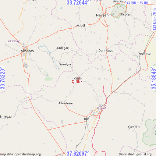
Çiftlik GPS coordinates[2]
38° 10' 32.88" North, 34° 29' 7.26" East
| Map corner | latitude | longitude |
|---|---|---|
| Upper-left | 38.72644°, | 33.78223° |
| Center: | 38.1758°, | 34.48535° |
| Lower-right: | 37.62097°, | 35.18848° |
| Map W x H: | 122.9×122.9 km | = 76.4×76.4mi |
| max Lat: | 42.02683° ⇑58.4% North |
| Çiftlik: | 38.1758° |
| min Lat: | ⇓41.6% South 35.9025° |
| min Long | Çiftlik | max Long |
| 25.90902° | 34.48535° | 44.60099° |
| W 43.5%⇐ | ⇒56.5% E |
Elevation
Elevation of Çiftlik is 1554 m = 5098 ft, and this is 836.6 m = 2745 ft above average elevation for this country.
| Max E: |
2682 m = 8799 ft | 7.5% |
| Çiftlik | 1554 m 5098 ft | |
| Avg. | 717.4 m = 2354 ft | |
Min E: |
0 m = 0 ft | 92.5% |
See also: Turkey elevation on elevation.city.
Geographical zone
Çiftlik is located in North temperate zone (between Tropic of Cancer and the Arctic Circle). Distance of this Northern Tropic circle is 1638.8 km =1018.3 mi to South.| Distance of | km | miles | from Çiftlik |
|---|---|---|---|
| North Pole | 5762.3 | 3580.5 | to North |
| Arctic Circle | 3156.4 | 1961.3 | to North |
| Tropic Cancer | 1638.8 | 1018.3 | to South |
| Equator | 4244.8 | 2637.6 | to South |


Nearby cities:
15 places around Çiftlik: (largest is in red/bold)
• Acıgöl
41.7 km =25.9 mi,  2°
2°
• Aksaray
45.7 km =28.4 mi,  298°
298°
• Altunhisar
22.7 km =14.1 mi,  205°
205°
• Bor
32.4 km =20.1 mi,  168°
168°
• Derinkuyu
31 km =19.3 mi,  44°
44°
• Göreme
60.3 km =37.5 mi,  30°
30°
• Gülağaç
27.3 km =17 mi,  333°
333°
• Güzelyurt
15 km =9.3 mi,  318°
318°
• Kemerhisar
39.9 km =24.8 mi, 169°
• Misli
26.2 km =16.3 mi,  76°
76°
• Nevşehir
53.7 km =33.4 mi,  21°
21°
• Niğde
28.9 km =18 mi,  143°
143°
• Taşpınar
40.2 km =25 mi,  270°
270°
• Yeşilhisar
56.2 km =34.9 mi,  69°
69°
• Çamardı
57.9 km =36 mi,  131°
131°
Sources, notices
• [Note1] Compared only with cities in Turkey existing in our database
• [Src1] Map data: © OpenStreetMap contributors (CC-BY-SA)
• [Src2] Other city data from geonames.org with taken over terms of usage.
• [Src3] Geographical zone / Annual Mean Temperature by Robert A. Rohde @ Wikipedia
