Bağpınar geodata
Bağpınar (Adıyaman) is a seat of a third-order administrative division; located in Turkey in Europe/Istanbul (GMT+3) time zone. In our database, there are 1323 cities with bigger population. Compared to other cities in Turkey, 72.2% of cities are located further ↑North; 63.1% of cities are located further ←West and 55.4% of cities have higher elevation than Bağpınar. Note1


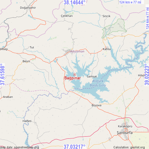
Bağpınar GPS coordinates[2]
37° 35' 29.004" North, 38° 19' 8.76" East
| Map corner | latitude | longitude |
|---|---|---|
| Upper-left | 38.14644°, | 37.61598° |
| Center: | 37.59139°, | 38.3191° |
| Lower-right: | 37.03217°, | 39.02223° |
| Map W x H: | 123.9×123.9 km | = 77×77mi |
| max Lat: | 42.02683° ⇑72.2% North |
| Bağpınar: | 37.59139° |
| min Lat: | ⇓27.8% South 35.9025° |
| min Long | Bağpınar | max Long |
| 25.90902° | 38.3191° | 44.60099° |
| W 63.1%⇐ | ⇒36.9% E |
Elevation
Elevation of Bağpınar is 579 m = 1900 ft, and this is 138.4 m = 454 ft below average elevation for this country.
| Max E: |
2682 m = 8799 ft | 55.4% |
| Avg. | 717.4 m = 2354 ft | |
| Bağpınar | 579 m = 1900 ft | |
Min E: |
0 m = 0 ft | 44.6% |
See also: Turkey elevation on elevation.city.
Geographical zone
Bağpınar is located in North temperate zone (between Tropic of Cancer and the Arctic Circle). Distance of this Northern Tropic circle is 1573.9 km =978 mi to South.| Distance of | km | miles | from Bağpınar |
|---|---|---|---|
| North Pole | 5827.3 | 3620.9 | to North |
| Arctic Circle | 3221.4 | 2001.7 | to North |
| Tropic Cancer | 1573.9 | 978 | to South |
| Equator | 4179.8 | 2597.2 | to South |


Nearby cities:
15 places around Bağpınar: (largest is in red/bold)
• Adıyaman
19.6 km =12.2 mi,  348°
348°
• Akpınar
8.9 km =5.5 mi,  257°
257°
• Besni
41.9 km =26 mi,  285°
285°
• Bozova
31.4 km =19.5 mi,  144°
144°
• Kanlıavşar
41.7 km =25.9 mi,  181°
181°
• Keysun
41 km =25.5 mi,  265°
265°
• Koçali
37.3 km =23.2 mi, 351°
• Kuyucak
30.3 km =18.8 mi,  4°
4°
• Kâhta
34.4 km =21.4 mi,  51°
51°
• Kızılin
22 km =13.7 mi, 257°
• Ovacık
41.5 km =25.8 mi,  102°
102°
• Samsat
13.7 km =8.5 mi,  94°
94°
• Tut
42.1 km =26.2 mi,  302°
302°
• Yaylak
23.3 km =14.5 mi, 175°
• Şambayat
26.1 km =16.2 mi, 293°
Sources, notices
• [Note1] Compared only with cities in Turkey existing in our database
• [Src1] Map data: © OpenStreetMap contributors (CC-BY-SA)
• [Src2] Other city data from geonames.org with taken over terms of usage.
• [Src3] Geographical zone / Annual Mean Temperature by Robert A. Rohde @ Wikipedia
