Yaylak geodata
Yaylak (Şanlıurfa) is a seat of a third-order administrative division; located in Turkey in Europe/Istanbul (GMT+3) time zone. In our database, there are 1323 cities with bigger population. Compared to other cities in Turkey, 78.1% of cities are located further ↑North; 63.2% of cities are located further ←West and 59.8% of cities have higher elevation than Yaylak. Note1


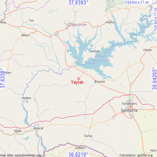
Yaylak GPS coordinates[2]
37° 22' 57.648" North, 38° 20' 20.112" East
| Map corner | latitude | longitude |
|---|---|---|
| Upper-left | 37.9393°, | 37.6358° |
| Center: | 37.38268°, | 38.33892° |
| Lower-right: | 36.8219°, | 39.04205° |
| Map W x H: | 124.2×124.2 km | = 77.2×77.2mi |
| max Lat: | 42.02683° ⇑78.1% North |
| Yaylak: | 37.38268° |
| min Lat: | ⇓21.9% South 35.9025° |
| min Long | Yaylak | max Long |
| 25.90902° | 38.33892° | 44.60099° |
| W 63.2%⇐ | ⇒36.8% E |
Elevation
Elevation of Yaylak is 510 m = 1673 ft, and this is 207.4 m = 680 ft below average elevation for this country.
| Max E: |
2682 m = 8799 ft | 59.8% |
| Avg. | 717.4 m = 2354 ft | |
| Yaylak | 510 m = 1673 ft | |
Min E: |
0 m = 0 ft | 40.2% |
See also: Turkey elevation on elevation.city.
Geographical zone
Yaylak is located in North temperate zone (between Tropic of Cancer and the Arctic Circle). Distance of this Northern Tropic circle is 1550.6 km =963.5 mi to South.| Distance of | km | miles | from Yaylak |
|---|---|---|---|
| North Pole | 5850.5 | 3635.3 | to North |
| Arctic Circle | 3244.6 | 2016.1 | to North |
| Tropic Cancer | 1550.6 | 963.5 | to South |
| Equator | 4156.6 | 2582.8 | to South |


Nearby cities:
15 places around Yaylak: (largest is in red/bold)
• Adıyaman
42.8 km =26.6 mi,  352°
352°
• Akpınar
23.7 km =14.7 mi,  333°
333°
• Akziyaret
40.5 km =25.2 mi,  94°
94°
• Bağpınar
23.3 km =14.5 mi,  355°
355°
• Bozova
16.7 km =10.4 mi,  97°
97°
• Böğürtlen
33.2 km =20.6 mi,  223°
223°
• Halfeti
44.3 km =27.5 mi,  249°
249°
• Kanlıavşar
18.7 km =11.6 mi,  188°
188°
• Karaköprü
45.3 km =28.1 mi,  116°
116°
• Kızılin
29.5 km =18.3 mi,  308°
308°
• Ovacık
41.5 km =25.8 mi,  69°
69°
• Payamlı
45.5 km =28.3 mi,  147°
147°
• Samsat
25.2 km =15.7 mi,  28°
28°
• Yonlyu
45.1 km =28 mi,  175°
175°
• Şambayat
42.3 km =26.3 mi,  322°
322°
Sources, notices
• [Note1] Compared only with cities in Turkey existing in our database
• [Src1] Map data: © OpenStreetMap contributors (CC-BY-SA)
• [Src2] Other city data from geonames.org with taken over terms of usage.
• [Src3] Geographical zone / Annual Mean Temperature by Robert A. Rohde @ Wikipedia
