Pazaryolu geodata
Pazaryolu (Erzurum) is a seat of a second-order administrative division; located in Turkey in Europe/Istanbul (GMT+3) time zone. With population of 5,878 people, there are 662 cities with bigger population in this country. Compared to other cities in Turkey, 76.4% of cities are located further ↓South; 79.1% of cities are located further ←West and 91% of cities have lower elevation than Pazaryolu. Note1


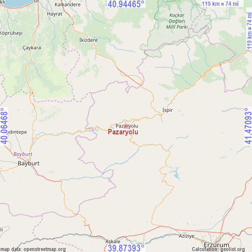
Pazaryolu GPS coordinates[2]
40° 24' 41.112" North, 40° 46' 4.08" East
| Map corner | latitude | longitude |
|---|---|---|
| Upper-left | 40.94465°, | 40.06468° |
| Center: | 40.41142°, | 40.7678° |
| Lower-right: | 39.87393°, | 41.47093° |
| Map W x H: | 119.1×119.1 km | = 74×74mi |
| max Lat: | 42.02683° ⇑23.6% North |
| Pazaryolu: | 40.41142° |
| min Lat: | ⇓76.4% South 35.9025° |
| min Long | Pazaryolu | max Long |
| 25.90902° | 40.7678° | 44.60099° |
| W 79.1%⇐ | ⇒20.9% E |
Elevation
Elevation of Pazaryolu is 1507 m = 4944 ft, and this is 789.6 m = 2591 ft above average elevation for this country.
| Max E: |
2682 m = 8799 ft | 9% |
| Pazaryolu | 1507 m 4944 ft | |
| Avg. | 717.4 m = 2354 ft | |
Min E: |
0 m = 0 ft | 91% |
See also: Turkey elevation on elevation.city.
Geographical zone
Pazaryolu is located in North temperate zone (between Tropic of Cancer and the Arctic Circle). Distance of this Northern Tropic circle is 1887.4 km =1172.8 mi to South.| Distance of | km | miles | from Pazaryolu |
|---|---|---|---|
| North Pole | 5513.7 | 3426.1 | to North |
| Arctic Circle | 2907.8 | 1806.8 | to North |
| Tropic Cancer | 1887.4 | 1172.8 | to South |
| Equator | 4493.3 | 2792 | to South |


Nearby cities:
15 places around Pazaryolu: (largest is in red/bold)
• Aydıntepe
53 km =32.9 mi,  266°
266°
• Aşkale
54.9 km =34.1 mi,  186°
186°
• Bayburt
49.3 km =30.6 mi,  249°
249°
• Güneyce
52 km =32.3 mi,  331°
331°
• Ilıca
58.7 km =36.5 mi,  151°
151°
• Kandilli
56.5 km =35.1 mi,  174°
174°
• Kırık
15.8 km =9.8 mi,  125°
125°
• Maden
40.1 km =24.9 mi,  230°
230°
• Ovacık
30.5 km =19 mi,  140°
140°
• Uzungöl
46.5 km =28.9 mi,  299°
299°
• Çamlıkaya
41.2 km =25.6 mi,  52°
52°
• Çaykara
58.4 km =36.3 mi,  309°
309°
• İkizdere
44.3 km =27.5 mi,  335°
335°
• İspir
20.6 km =12.8 mi,  68°
68°
• Şenyurt
55.9 km =34.7 mi,  88°
88°
Sources, notices
• [Note1] Compared only with cities in Turkey existing in our database
• [Src1] Map data: © OpenStreetMap contributors (CC-BY-SA)
• [Src2] Other city data from geonames.org with taken over terms of usage.
• [Src3] Geographical zone / Annual Mean Temperature by Robert A. Rohde @ Wikipedia
