Çerçiler geodata
Çerçiler (Sinop) is a seat of a third-order administrative division; located in Turkey in Europe/Istanbul (GMT+3) time zone. In our database, there are 1323 cities with bigger population. Compared to other cities in Turkey, 96.4% of cities are located further ↓South; 53.3% of cities are located further →East and 56.4% of cities have lower elevation than Çerçiler. Note1


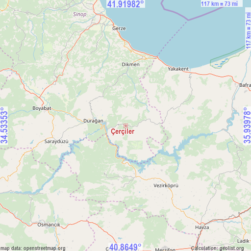
Çerçiler GPS coordinates[2]
41° 23' 40.2" North, 35° 14' 11.94" East
| Map corner | latitude | longitude |
|---|---|---|
| Upper-left | 41.91982°, | 34.53353° |
| Center: | 41.3945°, | 35.23665° |
| Lower-right: | 40.8649°, | 35.93978° |
| Map W x H: | 117.3×117.3 km | = 72.9×72.9mi |
| max Lat: | 42.02683° ⇑3.6% North |
| Çerçiler: | 41.3945° |
| min Lat: | ⇓96.4% South 35.9025° |
| min Long | Çerçiler | max Long |
| 25.90902° | 35.23665° | 44.60099° |
| W 46.7%⇐ | ⇒53.3% E |
Elevation
Elevation of Çerçiler is 818 m = 2684 ft, and this is 100.6 m = 330 ft above average elevation for this country.
| Max E: |
2682 m = 8799 ft | 43.6% |
| Çerçiler | 818 m 2684 ft | |
| Avg. | 717.4 m = 2354 ft | |
Min E: |
0 m = 0 ft | 56.4% |
See also: Turkey elevation on elevation.city.
Geographical zone
Çerçiler is located in North temperate zone (between Tropic of Cancer and the Arctic Circle). Distance of this Northern Tropic circle is 1996.7 km =1240.7 mi to South.| Distance of | km | miles | from Çerçiler |
|---|---|---|---|
| North Pole | 5404.4 | 3358.1 | to North |
| Arctic Circle | 2798.5 | 1738.9 | to North |
| Tropic Cancer | 1996.7 | 1240.7 | to South |
| Equator | 4602.6 | 2859.9 | to South |


Nearby cities:
15 places around Çerçiler: (largest is in red/bold)
• Alaçam
38.2 km =23.7 mi,  52°
52°
• Beşpınar
28.5 km =17.7 mi,  183°
183°
• Boyabat
40 km =24.9 mi,  281°
281°
• Dikmen
28.5 km =17.7 mi,  5°
5°
• Durağan
15.4 km =9.6 mi, 278°
• Gerze
45.6 km =28.3 mi,  356°
356°
• Kolay
47.2 km =29.3 mi,  86°
86°
• Kâmil
51.1 km =31.8 mi,  230°
230°
• Köprübaşı
45.1 km =28 mi,  148°
148°
• Mezraa
24.1 km =15 mi,  204°
204°
• Saraycık
50.5 km =31.4 mi,  191°
191°
• Saraydüzü
33.3 km =20.7 mi,  257°
257°
• Vezirköprü
33.3 km =20.7 mi, 146°
• Yakakent
35.9 km =22.3 mi,  42°
42°
• Çakıralan
50.5 km =31.4 mi,  119°
119°
Sources, notices
• [Note1] Compared only with cities in Turkey existing in our database
• [Src1] Map data: © OpenStreetMap contributors (CC-BY-SA)
• [Src2] Other city data from geonames.org with taken over terms of usage.
• [Src3] Geographical zone / Annual Mean Temperature by Robert A. Rohde @ Wikipedia
