İspir geodata
İspir (Erzurum) is a seat of a second-order administrative division; located in Turkey in Europe/Istanbul (GMT+3) time zone. With population of 12,906 people, there are 429 cities with bigger population in this country. Compared to other cities in Turkey, 77.3% of cities are located further ↓South; 81.3% of cities are located further ←West and 78.5% of cities have lower elevation than İspir. Note1


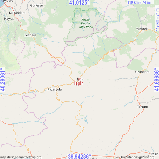
İspir GPS coordinates[2]
40° 28' 47.316" North, 40° 59' 37.428" East
| Map corner | latitude | longitude |
|---|---|---|
| Upper-left | 41.0125°, | 40.29061° |
| Center: | 40.47981°, | 40.99373° |
| Lower-right: | 39.94286°, | 41.69686° |
| Map W x H: | 118.9×118.9 km | = 73.9×73.9mi |
| max Lat: | 42.02683° ⇑22.7% North |
| İspir: | 40.47981° |
| min Lat: | ⇓77.3% South 35.9025° |
| min Long | İspir | max Long |
| 25.90902° | 40.99373° | 44.60099° |
| W 81.3%⇐ | ⇒18.7% E |
Elevation
Elevation of İspir is 1163 m = 3816 ft, and this is 445.6 m = 1462 ft above average elevation for this country.
| Max E: |
2682 m = 8799 ft | 21.5% |
| İspir | 1163 m 3816 ft | |
| Avg. | 717.4 m = 2354 ft | |
Min E: |
0 m = 0 ft | 78.5% |
See also: Turkey elevation on elevation.city.
Geographical zone
İspir is located in North temperate zone (between Tropic of Cancer and the Arctic Circle). Distance of this Northern Tropic circle is 1895 km =1177.5 mi to South.| Distance of | km | miles | from İspir |
|---|---|---|---|
| North Pole | 5506.1 | 3421.3 | to North |
| Arctic Circle | 2900.2 | 1802.1 | to North |
| Tropic Cancer | 1895 | 1177.5 | to South |
| Equator | 4500.9 | 2796.7 | to South |


Nearby cities:
15 places around İspir: (largest is in red/bold)
• Dumlu
56 km =34.8 mi,  146°
146°
• Güneyce
58.2 km =36.2 mi,  310°
310°
• Ilıca
59.9 km =37.2 mi,  171°
171°
• Kaptanpaşa
56.4 km =35 mi,  341°
341°
• Kılıçkaya
47.6 km =29.6 mi,  58°
58°
• Kırık
18 km =11.2 mi,  200°
200°
• Maden
60 km =37.3 mi,  236°
236°
• Ovacık
31.1 km =19.3 mi,  179°
179°
• Pazaryolu
20.6 km =12.8 mi,  248°
248°
• Tortum
51 km =31.7 mi,  114°
114°
• Uzundere
46.4 km =28.8 mi,  82°
82°
• Yusufeli
59.5 km =37 mi,  50°
50°
• Çamlıkaya
22.2 km =13.8 mi,  37°
37°
• İkizdere
49.6 km =30.8 mi, 311°
• Şenyurt
37.2 km =23.1 mi,  99°
99°
Sources, notices
• [Note1] Compared only with cities in Turkey existing in our database
• [Src1] Map data: © OpenStreetMap contributors (CC-BY-SA)
• [Src2] Other city data from geonames.org with taken over terms of usage.
• [Src3] Geographical zone / Annual Mean Temperature by Robert A. Rohde @ Wikipedia
