Yenikonak geodata
Yenikonak (Sinop) is a seat of a third-order administrative division; located in Turkey in Europe/Istanbul (GMT+3) time zone. In our database, there are 1323 cities with bigger population. Compared to other cities in Turkey, 99.3% of cities are located further ↓South; 56% of cities are located further →East and 78.2% of cities have higher elevation than Yenikonak. Note1


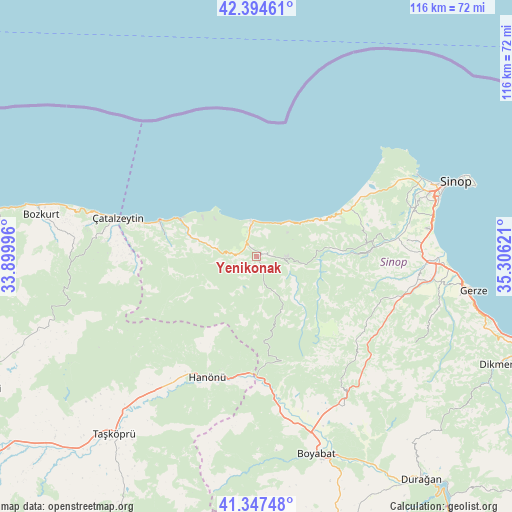
Yenikonak GPS coordinates[2]
41° 52' 23.484" North, 34° 36' 11.088" East
| Map corner | latitude | longitude |
|---|---|---|
| Upper-left | 42.39461°, | 33.89996° |
| Center: | 41.87319°, | 34.60308° |
| Lower-right: | 41.34748°, | 35.30621° |
| Map W x H: | 116.4×116.4 km | = 72.3×72.3mi |
| max Lat: | 42.02683° ⇑0.7% North |
| Yenikonak: | 41.87319° |
| min Lat: | ⇓99.3% South 35.9025° |
| min Long | Yenikonak | max Long |
| 25.90902° | 34.60308° | 44.60099° |
| W 44%⇐ | ⇒56% E |
Elevation
Elevation of Yenikonak is 135 m = 443 ft, and this is 582.4 m = 1911 ft below average elevation for this country.
| Max E: |
2682 m = 8799 ft | 78.2% |
| Avg. | 717.4 m = 2354 ft | |
| Yenikonak | 135 m = 443 ft | |
Min E: |
0 m = 0 ft | 21.8% |
See also: Turkey elevation on elevation.city.
Geographical zone
Yenikonak is located in North temperate zone (between Tropic of Cancer and the Arctic Circle). Distance of this Northern Tropic circle is 2049.9 km =1273.7 mi to South.| Distance of | km | miles | from Yenikonak |
|---|---|---|---|
| North Pole | 5351.2 | 3325.1 | to North |
| Arctic Circle | 2745.3 | 1705.8 | to North |
| Tropic Cancer | 2049.9 | 1273.7 | to South |
| Equator | 4655.9 | 2893 | to South |


Nearby cities:
15 places around Yenikonak: (largest is in red/bold)
• Abana
50.4 km =31.3 mi,  283°
283°
• Ayancık
8.1 km =5 mi,  349°
349°
• Boyabat
47 km =29.2 mi,  163°
163°
• Bozkurt
49.9 km =31 mi, 280°
• Dikmen
60.4 km =37.5 mi,  114°
114°
• Durağan
63.2 km =39.3 mi,  143°
143°
• Erfelek
26.1 km =16.2 mi,  88°
88°
• Gerze
50.1 km =31.1 mi,  98°
98°
• Güzelkent
19.2 km =11.9 mi,  295°
295°
• Hanönü
29.6 km =18.4 mi,  202°
202°
• Kabalı
38.1 km =23.7 mi, 93°
• Sinop
49.3 km =30.6 mi,  69°
69°
• Taşköprü
51.7 km =32.1 mi,  218°
218°
• Türkeli
23.4 km =14.5 mi,  290°
290°
• Çatalzeytin
33.2 km =20.6 mi, 285°
Sources, notices
• [Note1] Compared only with cities in Turkey existing in our database
• [Src1] Map data: © OpenStreetMap contributors (CC-BY-SA)
• [Src2] Other city data from geonames.org with taken over terms of usage.
• [Src3] Geographical zone / Annual Mean Temperature by Robert A. Rohde @ Wikipedia
